You are here: Home > Network List > AV - Alaska Volcano Observatory Stations List
> Station MNAT Nateekin Bay, Makushin Volcano, Alaska > Earthquake Result Viewer
MNAT Nateekin Bay, Makushin Volcano, Alaska - Earthquake Result Viewer
| Earthquake location: |
Eastern New Guinea Reg., P.N.G. |
| Earthquake latitude/longitude: |
-5.6/146.1 |
| Earthquake time(UTC): |
2023/10/07 (280) 08:34:26 GMT |
| Earthquake Depth: |
53 km |
| Earthquake Magnitude: |
6.7 mww |
| Earthquake Catalog/Contributor: |
NEIC PDE/us |
|
| Network: |
AV Alaska Volcano Observatory |
| Station: |
MNAT Nateekin Bay, Makushin Volcano, Alaska |
| Lat/Lon: |
53.88 N/166.69 W |
| Elevation: |
390 m |
|
| Distance: |
71.2 deg |
| Az: |
27.307 deg |
| Baz: |
230.466 deg |
| Ray Param: |
0.054387514 |
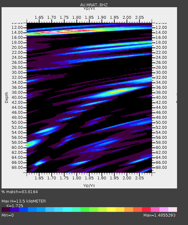
| Estimated Moho Depth: |
13.5 km |
| Estimated Crust Vp/Vs: |
1.73 |
| Assumed Crust Vp: |
3.943 km/s |
| Estimated Crust Vs: |
2.286 km/s |
| Estimated Crust Poisson's Ratio: |
0.25 |
|
| Radial Match: |
83.8164 % |
| Radial Bump: |
400 |
| Transverse Match: |
72.90952 % |
| Transverse Bump: |
400 |
| SOD ConfigId: |
31937991 |
| Insert Time: |
2023-10-21 08:59:45.644 +0000 |
| GWidth: |
2.5 |
| Max Bumps: |
400 |
| Tol: |
0.001 |
|
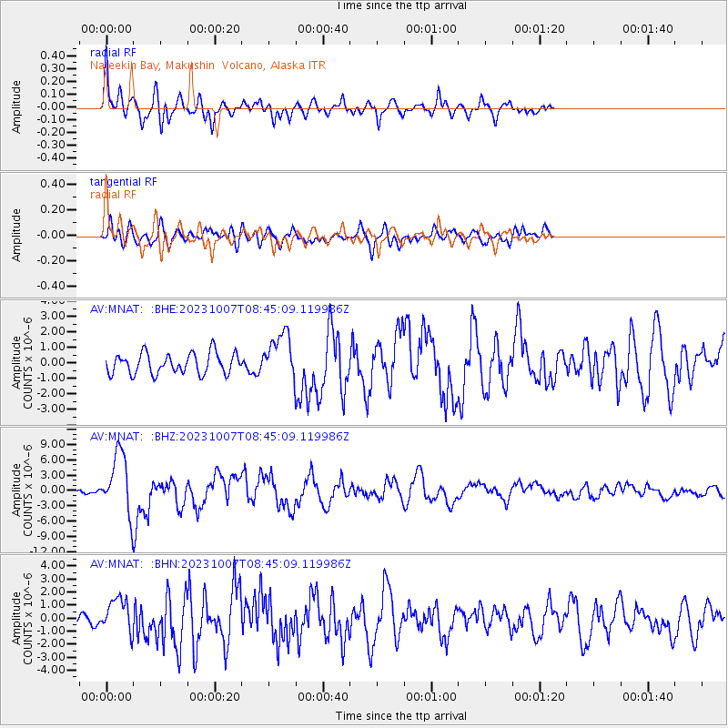
Signal To Noise
| Channel | StoN | STA | LTA |
| AV:MNAT: :BHZ:20231007T08:45:09.119986Z | 9.621004 | 5.9196623E-6 | 6.152853E-7 |
| AV:MNAT: :BHN:20231007T08:45:09.119986Z | 1.8342683 | 1.3425326E-6 | 7.319173E-7 |
| AV:MNAT: :BHE:20231007T08:45:09.119986Z | 2.2434938 | 1.4956339E-6 | 6.666539E-7 |
| Arrivals |
| Ps | 2.5 SECOND |
| PpPs | 9.2 SECOND |
| PsPs/PpSs | 12 SECOND |


