You are here: Home > Network List > AV - Alaska Volcano Observatory Stations List
> Station S12K Black Hills, AK, USA > Earthquake Result Viewer
S12K Black Hills, AK, USA - Earthquake Result Viewer
| Earthquake location: |
Eastern New Guinea Reg., P.N.G. |
| Earthquake latitude/longitude: |
-5.6/146.1 |
| Earthquake time(UTC): |
2023/10/07 (280) 08:34:26 GMT |
| Earthquake Depth: |
53 km |
| Earthquake Magnitude: |
6.7 mww |
| Earthquake Catalog/Contributor: |
NEIC PDE/us |
|
| Network: |
AV Alaska Volcano Observatory |
| Station: |
S12K Black Hills, AK, USA |
| Lat/Lon: |
55.70 N/162.06 W |
| Elevation: |
411 m |
|
| Distance: |
74.4 deg |
| Az: |
27.506 deg |
| Baz: |
234.296 deg |
| Ray Param: |
0.05224443 |
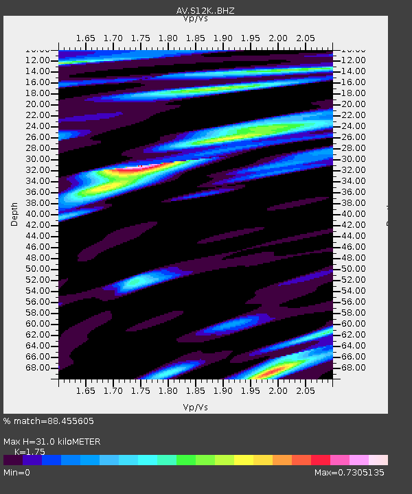
| Estimated Moho Depth: |
31.0 km |
| Estimated Crust Vp/Vs: |
1.75 |
| Assumed Crust Vp: |
5.989 km/s |
| Estimated Crust Vs: |
3.422 km/s |
| Estimated Crust Poisson's Ratio: |
0.26 |
|
| Radial Match: |
88.455605 % |
| Radial Bump: |
400 |
| Transverse Match: |
78.98276 % |
| Transverse Bump: |
400 |
| SOD ConfigId: |
31937991 |
| Insert Time: |
2023-10-21 09:01:24.729 +0000 |
| GWidth: |
2.5 |
| Max Bumps: |
400 |
| Tol: |
0.001 |
|

Signal To Noise
| Channel | StoN | STA | LTA |
| AV:S12K: :BHZ:20231007T08:45:28.200003Z | 14.054172 | 1.0391537E-5 | 7.393917E-7 |
| AV:S12K: :BHN:20231007T08:45:28.200003Z | 4.731648 | 2.3857883E-6 | 5.042194E-7 |
| AV:S12K: :BHE:20231007T08:45:28.200003Z | 4.058069 | 2.3837529E-6 | 5.874106E-7 |
| Arrivals |
| Ps | 4.0 SECOND |
| PpPs | 14 SECOND |
| PsPs/PpSs | 18 SECOND |


