You are here: Home > Network List > TA - USArray Transportable Network (new EarthScope stations) Stations List
> Station W36A Wetumka, OK, USA > Earthquake Result Viewer
W36A Wetumka, OK, USA - Earthquake Result Viewer
| Earthquake location: |
Tonga Islands |
| Earthquake latitude/longitude: |
-15.1/-173.5 |
| Earthquake time(UTC): |
2010/07/25 (206) 03:39:17 GMT |
| Earthquake Depth: |
7.0 km |
| Earthquake Magnitude: |
5.6 MB, 5.7 MS, 5.9 MW, 5.9 MW |
| Earthquake Catalog/Contributor: |
WHDF/NEIC |
|
| Network: |
TA USArray Transportable Network (new EarthScope stations) |
| Station: |
W36A Wetumka, OK, USA |
| Lat/Lon: |
35.14 N/96.23 W |
| Elevation: |
251 m |
|
| Distance: |
88.5 deg |
| Az: |
53.116 deg |
| Baz: |
250.528 deg |
| Ray Param: |
0.04252686 |
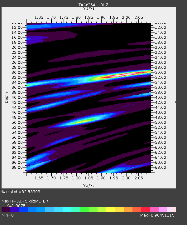
| Estimated Moho Depth: |
30.75 km |
| Estimated Crust Vp/Vs: |
1.99 |
| Assumed Crust Vp: |
6.426 km/s |
| Estimated Crust Vs: |
3.233 km/s |
| Estimated Crust Poisson's Ratio: |
0.33 |
|
| Radial Match: |
82.53398 % |
| Radial Bump: |
347 |
| Transverse Match: |
68.5582 % |
| Transverse Bump: |
362 |
| SOD ConfigId: |
319893 |
| Insert Time: |
2011-01-05 11:15:33.772 +0000 |
| GWidth: |
2.5 |
| Max Bumps: |
400 |
| Tol: |
0.001 |
|
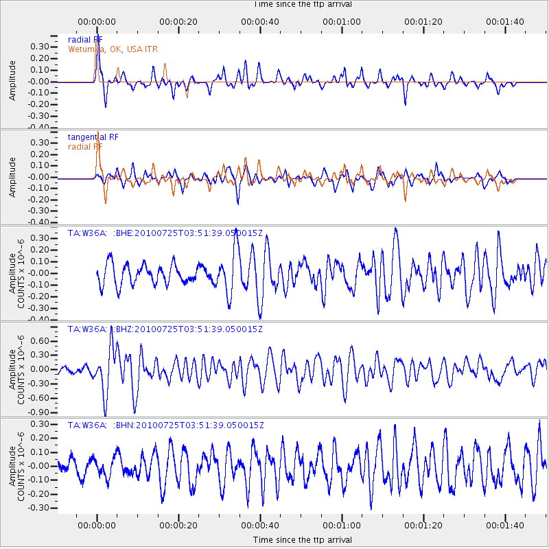
Signal To Noise
| Channel | StoN | STA | LTA |
| TA:W36A: :BHZ:20100725T03:51:39.050015Z | 8.624626 | 4.85588E-7 | 5.6302493E-8 |
| TA:W36A: :BHN:20100725T03:51:39.050015Z | 0.8447302 | 7.111805E-8 | 8.4190255E-8 |
| TA:W36A: :BHE:20100725T03:51:39.050015Z | 2.3679743 | 2.0049552E-7 | 8.466964E-8 |
| Arrivals |
| Ps | 4.8 SECOND |
| PpPs | 14 SECOND |
| PsPs/PpSs | 19 SECOND |


