You are here: Home > Network List > CI - Caltech Regional Seismic Network Stations List
> Station MPP McPhearson Peak > Earthquake Result Viewer
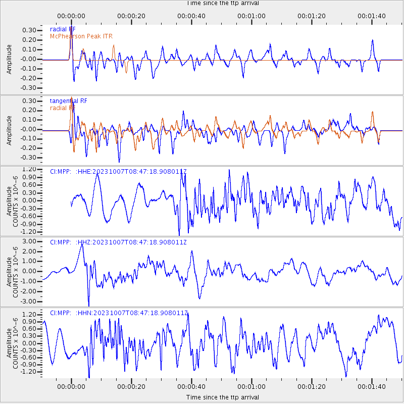
MPP McPhearson Peak - Earthquake Result Viewer
*The percent match for this event was below the threshold and hence no stack was calculated.
| Earthquake location: |
Eastern New Guinea Reg., P.N.G. |
| Earthquake latitude/longitude: |
-5.6/146.1 |
| Earthquake time(UTC): |
2023/10/07 (280) 08:34:26 GMT |
| Earthquake Depth: |
53 km |
| Earthquake Magnitude: |
6.7 mww |
| Earthquake Catalog/Contributor: |
NEIC PDE/us |
|
| Network: |
CI Caltech Regional Seismic Network |
| Station: |
MPP McPhearson Peak |
| Lat/Lon: |
34.89 N/119.81 W |
| Elevation: |
1739 m |
|
| Distance: |
96.5 deg |
| Az: |
55.619 deg |
| Baz: |
267.715 deg |
| Ray Param: |
$rayparam |
*The percent match for this event was below the threshold and hence was not used in the summary stack. |
|
| Radial Match: |
62.137386 % |
| Radial Bump: |
400 |
| Transverse Match: |
70.19978 % |
| Transverse Bump: |
400 |
| SOD ConfigId: |
31937991 |
| Insert Time: |
2023-10-21 09:08:50.513 +0000 |
| GWidth: |
2.5 |
| Max Bumps: |
400 |
| Tol: |
0.001 |
|
Signal To Noise
| Channel | StoN | STA | LTA |
| CI:MPP: :HHZ:20231007T08:47:18.908011Z | 4.366916 | 1.451333E-6 | 3.3234733E-7 |
| CI:MPP: :HHN:20231007T08:47:18.908011Z | 1.0638754 | 4.128667E-7 | 3.8807806E-7 |
| CI:MPP: :HHE:20231007T08:47:18.908011Z | 0.5566243 | 2.5596984E-7 | 4.5986104E-7 |
| Arrivals |
| Ps | |
| PpPs | |
| PsPs/PpSs | |


