You are here: Home > Network List > JP - Japan Meteorological Agency Seismic Network Stations List
> Station JCJ Chichijima Island > Earthquake Result Viewer
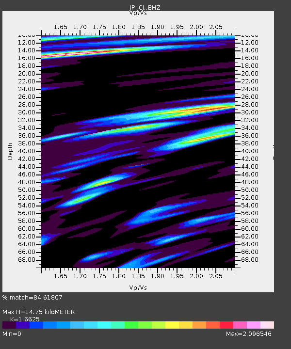
JCJ Chichijima Island - Earthquake Result Viewer
| Earthquake location: |
Eastern New Guinea Reg., P.N.G. |
| Earthquake latitude/longitude: |
-5.6/146.1 |
| Earthquake time(UTC): |
2023/10/07 (280) 08:34:26 GMT |
| Earthquake Depth: |
53 km |
| Earthquake Magnitude: |
6.7 mww |
| Earthquake Catalog/Contributor: |
NEIC PDE/us |
|
| Network: |
JP Japan Meteorological Agency Seismic Network |
| Station: |
JCJ Chichijima Island |
| Lat/Lon: |
27.10 N/142.18 E |
| Elevation: |
150 m |
|
| Distance: |
32.7 deg |
| Az: |
353.483 deg |
| Baz: |
172.72 deg |
| Ray Param: |
0.07841457 |
| Estimated Moho Depth: |
14.75 km |
| Estimated Crust Vp/Vs: |
1.66 |
| Assumed Crust Vp: |
4.24 km/s |
| Estimated Crust Vs: |
2.55 km/s |
| Estimated Crust Poisson's Ratio: |
0.22 |
|
| Radial Match: |
84.61807 % |
| Radial Bump: |
400 |
| Transverse Match: |
70.16622 % |
| Transverse Bump: |
400 |
| SOD ConfigId: |
31937991 |
| Insert Time: |
2023-10-21 09:16:08.507 +0000 |
| GWidth: |
2.5 |
| Max Bumps: |
400 |
| Tol: |
0.001 |
|

Signal To Noise
| Channel | StoN | STA | LTA |
| JP:JCJ: :BHZ:20231007T08:40:24.05001Z | 8.975547 | 7.8810257E-7 | 8.780552E-8 |
| JP:JCJ: :BHN:20231007T08:40:24.05001Z | 2.5388646 | 2.9921245E-7 | 1.17852856E-7 |
| JP:JCJ: :BHE:20231007T08:40:24.05001Z | 1.0621948 | 5.032601E-7 | 4.7379265E-7 |
| Arrivals |
| Ps | 2.4 SECOND |
| PpPs | 8.9 SECOND |
| PsPs/PpSs | 11 SECOND |


