You are here: Home > Network List > US - United States National Seismic Network Stations List
> Station DUG Dugway, Tooele County, Utah, USA > Earthquake Result Viewer
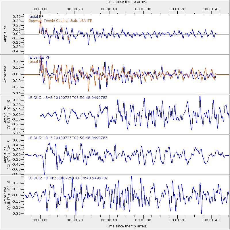
DUG Dugway, Tooele County, Utah, USA - Earthquake Result Viewer
*The percent match for this event was below the threshold and hence no stack was calculated.
| Earthquake location: |
Tonga Islands |
| Earthquake latitude/longitude: |
-15.1/-173.5 |
| Earthquake time(UTC): |
2010/07/25 (206) 03:39:17 GMT |
| Earthquake Depth: |
7.0 km |
| Earthquake Magnitude: |
5.6 MB, 5.7 MS, 5.9 MW, 5.9 MW |
| Earthquake Catalog/Contributor: |
WHDF/NEIC |
|
| Network: |
US United States National Seismic Network |
| Station: |
DUG Dugway, Tooele County, Utah, USA |
| Lat/Lon: |
40.19 N/112.81 W |
| Elevation: |
1477 m |
|
| Distance: |
78.7 deg |
| Az: |
42.952 deg |
| Baz: |
239.244 deg |
| Ray Param: |
$rayparam |
*The percent match for this event was below the threshold and hence was not used in the summary stack. |
|
| Radial Match: |
76.52039 % |
| Radial Bump: |
400 |
| Transverse Match: |
67.32327 % |
| Transverse Bump: |
400 |
| SOD ConfigId: |
319893 |
| Insert Time: |
2011-01-05 11:20:45.969 +0000 |
| GWidth: |
2.5 |
| Max Bumps: |
400 |
| Tol: |
0.001 |
|
Signal To Noise
| Channel | StoN | STA | LTA |
| US:DUG: :BHZ:20100725T03:50:48.949978Z | 6.633643 | 3.2534697E-7 | 4.9044992E-8 |
| US:DUG: :BHN:20100725T03:50:48.949978Z | 1.7643269 | 1.01997166E-7 | 5.7810805E-8 |
| US:DUG: :BHE:20100725T03:50:48.949978Z | 1.6063186 | 1.1573401E-7 | 7.2049225E-8 |
| Arrivals |
| Ps | |
| PpPs | |
| PsPs/PpSs | |


