You are here: Home > Network List > US - United States National Seismic Network Stations List
> Station CBKS Cedar Bluff, Kansas, USA > Earthquake Result Viewer
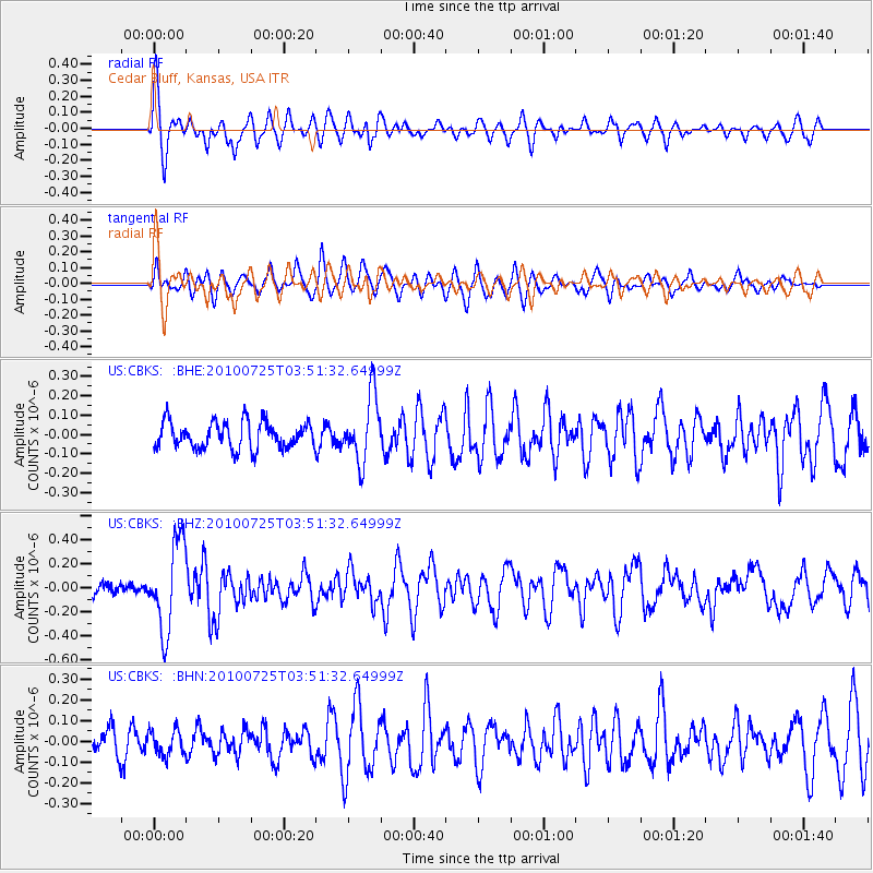
CBKS Cedar Bluff, Kansas, USA - Earthquake Result Viewer
*The percent match for this event was below the threshold and hence no stack was calculated.
| Earthquake location: |
Tonga Islands |
| Earthquake latitude/longitude: |
-15.1/-173.5 |
| Earthquake time(UTC): |
2010/07/25 (206) 03:39:17 GMT |
| Earthquake Depth: |
7.0 km |
| Earthquake Magnitude: |
5.6 MB, 5.7 MS, 5.9 MW, 5.9 MW |
| Earthquake Catalog/Contributor: |
WHDF/NEIC |
|
| Network: |
US United States National Seismic Network |
| Station: |
CBKS Cedar Bluff, Kansas, USA |
| Lat/Lon: |
38.81 N/99.74 W |
| Elevation: |
677 m |
|
| Distance: |
87.2 deg |
| Az: |
48.691 deg |
| Baz: |
248.258 deg |
| Ray Param: |
$rayparam |
*The percent match for this event was below the threshold and hence was not used in the summary stack. |
|
| Radial Match: |
72.87772 % |
| Radial Bump: |
400 |
| Transverse Match: |
65.38101 % |
| Transverse Bump: |
400 |
| SOD ConfigId: |
319893 |
| Insert Time: |
2011-01-05 11:21:11.056 +0000 |
| GWidth: |
2.5 |
| Max Bumps: |
400 |
| Tol: |
0.001 |
|
Signal To Noise
| Channel | StoN | STA | LTA |
| US:CBKS: :BHZ:20100725T03:51:32.64999Z | 6.8224077 | 3.65898E-7 | 5.3631798E-8 |
| US:CBKS: :BHN:20100725T03:51:32.64999Z | 0.7449135 | 5.9510004E-8 | 7.988847E-8 |
| US:CBKS: :BHE:20100725T03:51:32.64999Z | 2.4685977 | 1.6990265E-7 | 6.882557E-8 |
| Arrivals |
| Ps | |
| PpPs | |
| PsPs/PpSs | |


