You are here: Home > Network List > US - United States National Seismic Network Stations List
> Station HAWA Hanford, Washington, USA > Earthquake Result Viewer
HAWA Hanford, Washington, USA - Earthquake Result Viewer
*The percent match for this event was below the threshold and hence no stack was calculated.
| Earthquake location: |
Eastern New Guinea Reg., P.N.G. |
| Earthquake latitude/longitude: |
-5.6/146.1 |
| Earthquake time(UTC): |
2023/10/07 (280) 08:34:26 GMT |
| Earthquake Depth: |
53 km |
| Earthquake Magnitude: |
6.7 mww |
| Earthquake Catalog/Contributor: |
NEIC PDE/us |
|
| Network: |
US United States National Seismic Network |
| Station: |
HAWA Hanford, Washington, USA |
| Lat/Lon: |
46.39 N/119.53 W |
| Elevation: |
364 m |
|
| Distance: |
97.0 deg |
| Az: |
44.056 deg |
| Baz: |
269.262 deg |
| Ray Param: |
$rayparam |
*The percent match for this event was below the threshold and hence was not used in the summary stack. |
|
| Radial Match: |
74.548004 % |
| Radial Bump: |
400 |
| Transverse Match: |
53.393818 % |
| Transverse Bump: |
400 |
| SOD ConfigId: |
31937991 |
| Insert Time: |
2023-10-21 09:28:13.201 +0000 |
| GWidth: |
2.5 |
| Max Bumps: |
400 |
| Tol: |
0.001 |
|
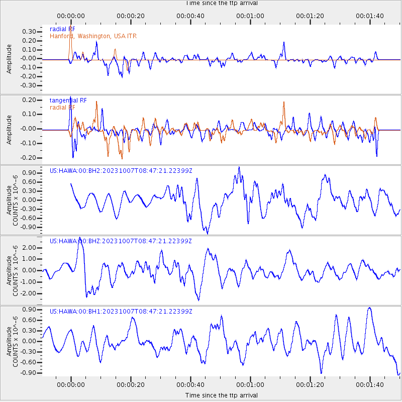
Signal To Noise
| Channel | StoN | STA | LTA |
| US:HAWA:00:BHZ:20231007T08:47:21.22399Z | 4.3201184 | 1.6010916E-6 | 3.7061292E-7 |
| US:HAWA:00:BH1:20231007T08:47:21.22399Z | 0.63612956 | 2.51892E-7 | 3.9597595E-7 |
| US:HAWA:00:BH2:20231007T08:47:21.22399Z | 1.0801797 | 2.549069E-7 | 2.3598565E-7 |
| Arrivals |
| Ps | |
| PpPs | |
| PsPs/PpSs | |


