You are here: Home > Network List > TX - Texas Seismological Network Stations List
> Station FW11 UT at Arlington > Earthquake Result Viewer
FW11 UT at Arlington - Earthquake Result Viewer
| Earthquake location: |
Near Coast Of Peru |
| Earthquake latitude/longitude: |
-14.5/-75.4 |
| Earthquake time(UTC): |
2019/01/25 (025) 04:45:21 GMT |
| Earthquake Depth: |
57 km |
| Earthquake Magnitude: |
5.6 Mww |
| Earthquake Catalog/Contributor: |
NEIC PDE/us |
|
| Network: |
TX Texas Seismological Network |
| Station: |
FW11 UT at Arlington |
| Lat/Lon: |
32.72 N/97.13 W |
| Elevation: |
198 m |
|
| Distance: |
51.4 deg |
| Az: |
336.443 deg |
| Baz: |
152.667 deg |
| Ray Param: |
0.06729891 |
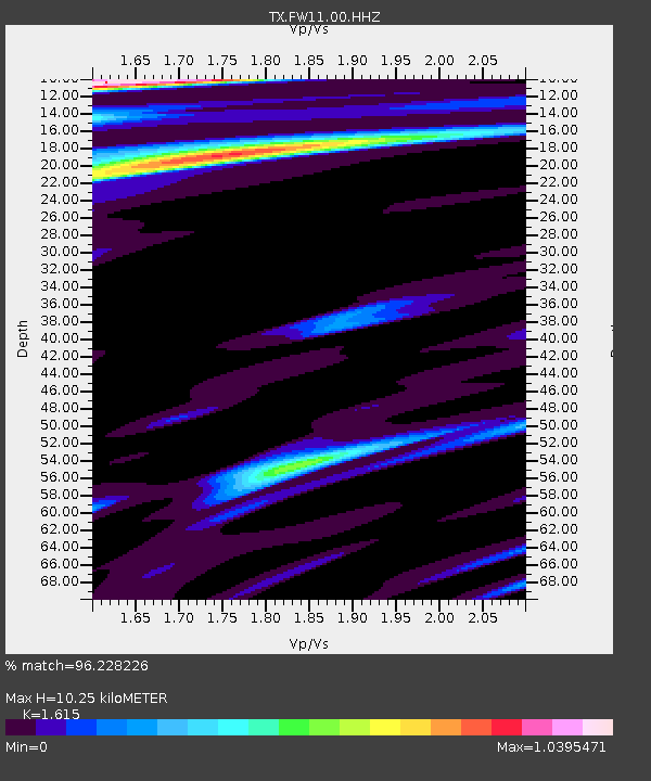
| Estimated Moho Depth: |
10.25 km |
| Estimated Crust Vp/Vs: |
1.62 |
| Assumed Crust Vp: |
6.38 km/s |
| Estimated Crust Vs: |
3.951 km/s |
| Estimated Crust Poisson's Ratio: |
0.19 |
|
| Radial Match: |
96.228226 % |
| Radial Bump: |
300 |
| Transverse Match: |
60.257263 % |
| Transverse Bump: |
400 |
| SOD ConfigId: |
3276131 |
| Insert Time: |
2019-02-08 04:51:38.906 +0000 |
| GWidth: |
2.5 |
| Max Bumps: |
400 |
| Tol: |
0.001 |
|
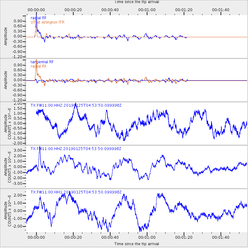
Signal To Noise
| Channel | StoN | STA | LTA |
| TX:FW11:00:HHZ:20190125T04:53:50.099998Z | 1.2473556 | 1.6004228E-6 | 1.2830527E-6 |
| TX:FW11:00:HH1:20190125T04:53:50.099998Z | 0.902247 | 1.3891754E-6 | 1.539684E-6 |
| TX:FW11:00:HH2:20190125T04:53:50.099998Z | 1.0403537 | 9.084462E-7 | 8.732091E-7 |
| Arrivals |
| Ps | 1.1 SECOND |
| PpPs | 4.0 SECOND |
| PsPs/PpSs | 5.0 SECOND |


