You are here: Home > Network List > AK - Alaska Regional Network Stations List
> Station D20K Etivluk River, AK, USA > Earthquake Result Viewer
D20K Etivluk River, AK, USA - Earthquake Result Viewer
| Earthquake location: |
Eastern New Guinea Reg., P.N.G. |
| Earthquake latitude/longitude: |
-5.5/146.2 |
| Earthquake time(UTC): |
2023/10/07 (280) 08:40:13 GMT |
| Earthquake Depth: |
74 km |
| Earthquake Magnitude: |
6.7 Mww |
| Earthquake Catalog/Contributor: |
NEIC PDE/us |
|
| Network: |
AK Alaska Regional Network |
| Station: |
D20K Etivluk River, AK, USA |
| Lat/Lon: |
68.71 N/156.61 W |
| Elevation: |
577 m |
|
| Distance: |
83.8 deg |
| Az: |
17.987 deg |
| Baz: |
237.333 deg |
| Ray Param: |
0.045795612 |
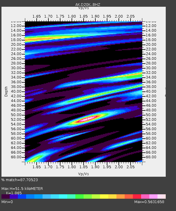
| Estimated Moho Depth: |
51.5 km |
| Estimated Crust Vp/Vs: |
1.87 |
| Assumed Crust Vp: |
6.221 km/s |
| Estimated Crust Vs: |
3.336 km/s |
| Estimated Crust Poisson's Ratio: |
0.30 |
|
| Radial Match: |
87.70523 % |
| Radial Bump: |
391 |
| Transverse Match: |
79.92797 % |
| Transverse Bump: |
400 |
| SOD ConfigId: |
31937991 |
| Insert Time: |
2023-10-21 09:39:20.762 +0000 |
| GWidth: |
2.5 |
| Max Bumps: |
400 |
| Tol: |
0.001 |
|

Signal To Noise
| Channel | StoN | STA | LTA |
| AK:D20K: :BHZ:20231007T08:52:03.600005Z | 9.219035 | 4.2976503E-6 | 4.6617137E-7 |
| AK:D20K: :BHN:20231007T08:52:03.600005Z | 2.9553618 | 9.935499E-7 | 3.361855E-7 |
| AK:D20K: :BHE:20231007T08:52:03.600005Z | 2.6701536 | 1.3471008E-6 | 5.045031E-7 |
| Arrivals |
| Ps | 7.3 SECOND |
| PpPs | 23 SECOND |
| PsPs/PpSs | 31 SECOND |


