You are here: Home > Network List > AK - Alaska Regional Network Stations List
> Station L16K Owhat River, AK, USA > Earthquake Result Viewer
L16K Owhat River, AK, USA - Earthquake Result Viewer
| Earthquake location: |
Eastern New Guinea Reg., P.N.G. |
| Earthquake latitude/longitude: |
-5.5/146.2 |
| Earthquake time(UTC): |
2023/10/07 (280) 08:40:13 GMT |
| Earthquake Depth: |
74 km |
| Earthquake Magnitude: |
6.7 Mww |
| Earthquake Catalog/Contributor: |
NEIC PDE/us |
|
| Network: |
AK Alaska Regional Network |
| Station: |
L16K Owhat River, AK, USA |
| Lat/Lon: |
61.71 N/159.47 W |
| Elevation: |
227 m |
|
| Distance: |
78.9 deg |
| Az: |
23.236 deg |
| Baz: |
235.526 deg |
| Ray Param: |
0.049190253 |
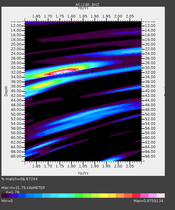
| Estimated Moho Depth: |
31.75 km |
| Estimated Crust Vp/Vs: |
1.76 |
| Assumed Crust Vp: |
6.276 km/s |
| Estimated Crust Vs: |
3.566 km/s |
| Estimated Crust Poisson's Ratio: |
0.26 |
|
| Radial Match: |
86.97244 % |
| Radial Bump: |
335 |
| Transverse Match: |
75.27339 % |
| Transverse Bump: |
400 |
| SOD ConfigId: |
31937991 |
| Insert Time: |
2023-10-21 09:42:11.606 +0000 |
| GWidth: |
2.5 |
| Max Bumps: |
400 |
| Tol: |
0.001 |
|

Signal To Noise
| Channel | StoN | STA | LTA |
| AK:L16K: :BHZ:20231007T08:51:37.800017Z | 10.514312 | 4.2524744E-6 | 4.0444627E-7 |
| AK:L16K: :BHN:20231007T08:51:37.800017Z | 2.2858703 | 1.0511856E-6 | 4.5986226E-7 |
| AK:L16K: :BHE:20231007T08:51:37.800017Z | 3.4010227 | 2.3456216E-6 | 6.8968126E-7 |
| Arrivals |
| Ps | 4.0 SECOND |
| PpPs | 14 SECOND |
| PsPs/PpSs | 18 SECOND |


