You are here: Home > Network List > AK - Alaska Regional Network Stations List
> Station L20K Alaska Regional Network > Earthquake Result Viewer
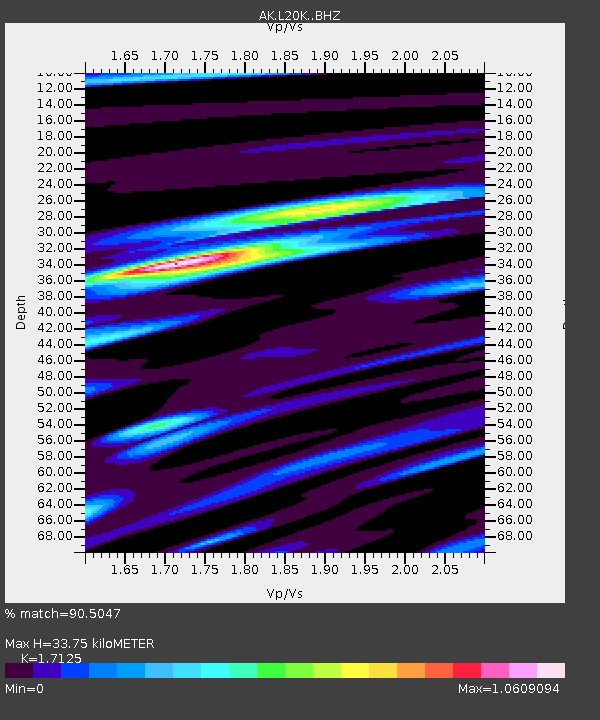
L20K Alaska Regional Network - Earthquake Result Viewer
| Earthquake location: |
Eastern New Guinea Reg., P.N.G. |
| Earthquake latitude/longitude: |
-5.5/146.2 |
| Earthquake time(UTC): |
2023/10/07 (280) 08:40:13 GMT |
| Earthquake Depth: |
74 km |
| Earthquake Magnitude: |
6.7 Mww |
| Earthquake Catalog/Contributor: |
NEIC PDE/us |
|
| Network: |
AK Alaska Regional Network |
| Station: |
L20K Alaska Regional Network |
| Lat/Lon: |
62.48 N/153.88 W |
| Elevation: |
673 m |
|
| Distance: |
81.5 deg |
| Az: |
23.985 deg |
| Baz: |
240.591 deg |
| Ray Param: |
0.047378834 |
| Estimated Moho Depth: |
33.75 km |
| Estimated Crust Vp/Vs: |
1.71 |
| Assumed Crust Vp: |
6.566 km/s |
| Estimated Crust Vs: |
3.834 km/s |
| Estimated Crust Poisson's Ratio: |
0.24 |
|
| Radial Match: |
90.5047 % |
| Radial Bump: |
391 |
| Transverse Match: |
80.0285 % |
| Transverse Bump: |
400 |
| SOD ConfigId: |
31937991 |
| Insert Time: |
2023-10-21 09:42:18.973 +0000 |
| GWidth: |
2.5 |
| Max Bumps: |
400 |
| Tol: |
0.001 |
|

Signal To Noise
| Channel | StoN | STA | LTA |
| AK:L20K: :BHZ:20231007T08:51:51.939971Z | 8.810968 | 4.7075246E-6 | 5.3428E-7 |
| AK:L20K: :BHN:20231007T08:51:51.939971Z | 2.97304 | 9.032557E-7 | 3.038155E-7 |
| AK:L20K: :BHE:20231007T08:51:51.939971Z | 3.5144086 | 1.7332666E-6 | 4.931887E-7 |
| Arrivals |
| Ps | 3.8 SECOND |
| PpPs | 14 SECOND |
| PsPs/PpSs | 17 SECOND |


