You are here: Home > Network List > AV - Alaska Volcano Observatory Stations List
> Station MAPS Pakushin Southeast, Makushin Volcano, Alaska > Earthquake Result Viewer
MAPS Pakushin Southeast, Makushin Volcano, Alaska - Earthquake Result Viewer
| Earthquake location: |
Eastern New Guinea Reg., P.N.G. |
| Earthquake latitude/longitude: |
-5.5/146.2 |
| Earthquake time(UTC): |
2023/10/07 (280) 08:40:13 GMT |
| Earthquake Depth: |
74 km |
| Earthquake Magnitude: |
6.7 Mww |
| Earthquake Catalog/Contributor: |
NEIC PDE/us |
|
| Network: |
AV Alaska Volcano Observatory |
| Station: |
MAPS Pakushin Southeast, Makushin Volcano, Alaska |
| Lat/Lon: |
53.81 N/166.94 W |
| Elevation: |
333 m |
|
| Distance: |
70.9 deg |
| Az: |
27.265 deg |
| Baz: |
230.258 deg |
| Ray Param: |
0.054501835 |
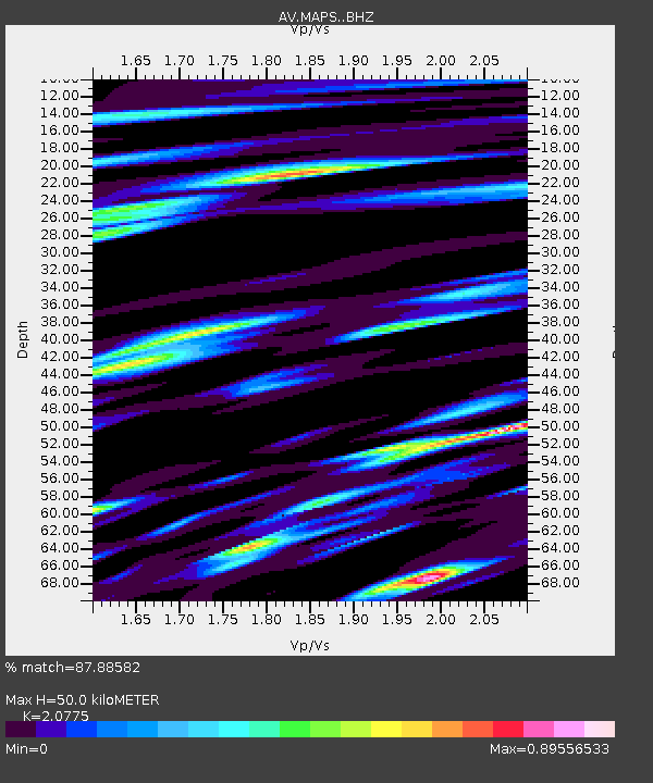
| Estimated Moho Depth: |
50.0 km |
| Estimated Crust Vp/Vs: |
2.08 |
| Assumed Crust Vp: |
3.943 km/s |
| Estimated Crust Vs: |
1.898 km/s |
| Estimated Crust Poisson's Ratio: |
0.35 |
|
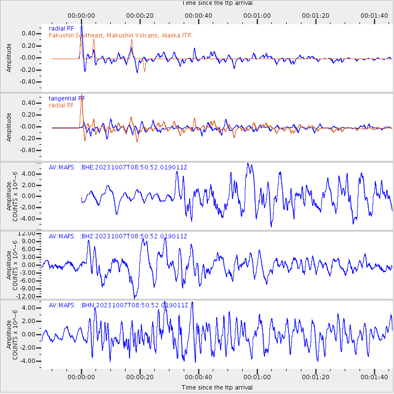
| Radial Match: |
87.88582 % |
| Radial Bump: |
400 |
| Transverse Match: |
73.4797 % |
| Transverse Bump: |
400 |
| SOD ConfigId: |
31937991 |
| Insert Time: |
2023-10-21 09:51:53.737 +0000 |
| GWidth: |
2.5 |
| Max Bumps: |
400 |
| Tol: |
0.001 |
|
Signal To Noise
| Channel | StoN | STA | LTA |
| AV:MAPS: :BHZ:20231007T08:50:52.019011Z | 3.3831747 | 4.2767256E-6 | 1.2641161E-6 |
| AV:MAPS: :BHN:20231007T08:50:52.019011Z | 2.4118676 | 1.8469278E-6 | 7.657667E-7 |
| AV:MAPS: :BHE:20231007T08:50:52.019011Z | 1.915316 | 1.8683969E-6 | 9.755032E-7 |
| Arrivals |
| Ps | 14 SECOND |
| PpPs | 39 SECOND |
| PsPs/PpSs | 52 SECOND |


