You are here: Home > Network List > AV - Alaska Volcano Observatory Stations List
> Station MGLS Mageik Landslide, Katmai, Volcanic Group, Alaska > Earthquake Result Viewer
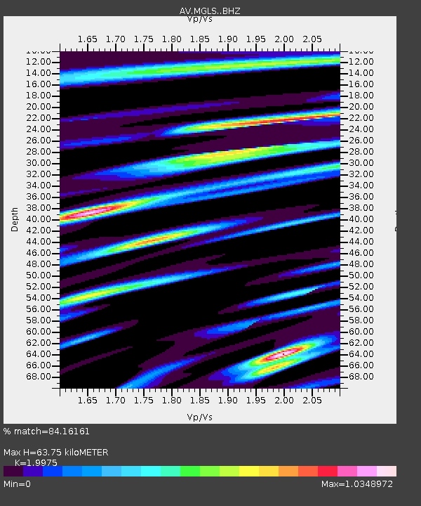
MGLS Mageik Landslide, Katmai, Volcanic Group, Alaska - Earthquake Result Viewer
| Earthquake location: |
Eastern New Guinea Reg., P.N.G. |
| Earthquake latitude/longitude: |
-5.5/146.2 |
| Earthquake time(UTC): |
2023/10/07 (280) 08:40:13 GMT |
| Earthquake Depth: |
74 km |
| Earthquake Magnitude: |
6.7 Mww |
| Earthquake Catalog/Contributor: |
NEIC PDE/us |
|
| Network: |
AV Alaska Volcano Observatory |
| Station: |
MGLS Mageik Landslide, Katmai, Volcanic Group, Alaska |
| Lat/Lon: |
58.13 N/155.16 W |
| Elevation: |
472 m |
|
| Distance: |
78.8 deg |
| Az: |
27.509 deg |
| Baz: |
240.08 deg |
| Ray Param: |
0.0492371 |
| Estimated Moho Depth: |
63.75 km |
| Estimated Crust Vp/Vs: |
2.00 |
| Assumed Crust Vp: |
6.438 km/s |
| Estimated Crust Vs: |
3.223 km/s |
| Estimated Crust Poisson's Ratio: |
0.33 |
|
| Radial Match: |
84.16161 % |
| Radial Bump: |
400 |
| Transverse Match: |
83.59622 % |
| Transverse Bump: |
400 |
| SOD ConfigId: |
31937991 |
| Insert Time: |
2023-10-21 09:52:00.384 +0000 |
| GWidth: |
2.5 |
| Max Bumps: |
400 |
| Tol: |
0.001 |
|

Signal To Noise
| Channel | StoN | STA | LTA |
| AV:MGLS: :BHZ:20231007T08:51:37.399993Z | 6.6234465 | 4.3221276E-6 | 6.525496E-7 |
| AV:MGLS: :BHN:20231007T08:51:37.399993Z | 3.840227 | 2.0542184E-6 | 5.349211E-7 |
| AV:MGLS: :BHE:20231007T08:51:37.399993Z | 2.6557133 | 1.768504E-6 | 6.659243E-7 |
| Arrivals |
| Ps | 10 SECOND |
| PpPs | 29 SECOND |
| PsPs/PpSs | 39 SECOND |


