You are here: Home > Network List > AV - Alaska Volcano Observatory Stations List
> Station SPNN North Nagishlamina, Mount Spurr, Alaska > Earthquake Result Viewer
SPNN North Nagishlamina, Mount Spurr, Alaska - Earthquake Result Viewer
| Earthquake location: |
Eastern New Guinea Reg., P.N.G. |
| Earthquake latitude/longitude: |
-5.5/146.2 |
| Earthquake time(UTC): |
2023/10/07 (280) 08:40:13 GMT |
| Earthquake Depth: |
74 km |
| Earthquake Magnitude: |
6.7 Mww |
| Earthquake Catalog/Contributor: |
NEIC PDE/us |
|
| Network: |
AV Alaska Volcano Observatory |
| Station: |
SPNN North Nagishlamina, Mount Spurr, Alaska |
| Lat/Lon: |
61.37 N/152.70 W |
| Elevation: |
1666 m |
|
| Distance: |
81.5 deg |
| Az: |
25.246 deg |
| Baz: |
241.816 deg |
| Ray Param: |
0.047413755 |
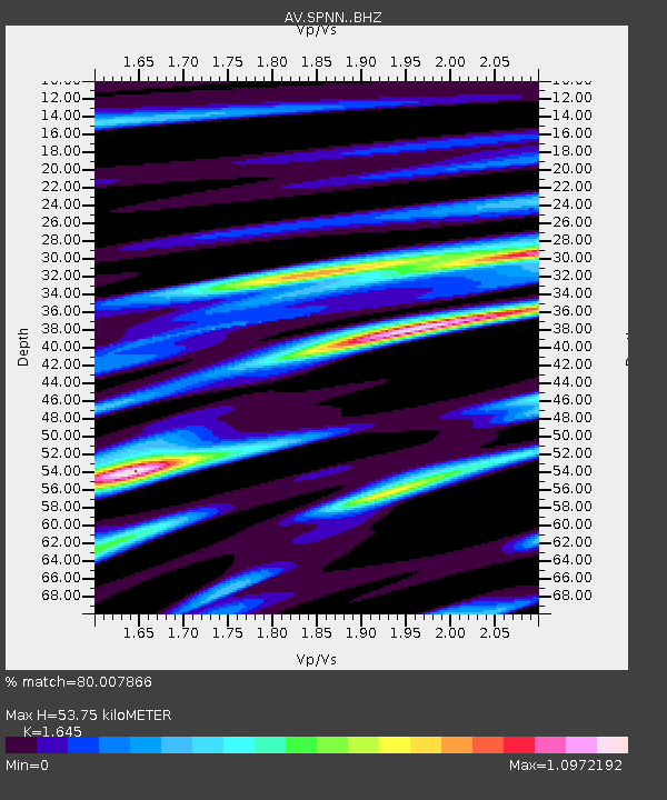
| Estimated Moho Depth: |
53.75 km |
| Estimated Crust Vp/Vs: |
1.64 |
| Assumed Crust Vp: |
6.566 km/s |
| Estimated Crust Vs: |
3.992 km/s |
| Estimated Crust Poisson's Ratio: |
0.21 |
|
| Radial Match: |
80.007866 % |
| Radial Bump: |
400 |
| Transverse Match: |
75.67838 % |
| Transverse Bump: |
400 |
| SOD ConfigId: |
31937991 |
| Insert Time: |
2023-10-21 09:54:03.885 +0000 |
| GWidth: |
2.5 |
| Max Bumps: |
400 |
| Tol: |
0.001 |
|

Signal To Noise
| Channel | StoN | STA | LTA |
| AV:SPNN: :BHZ:20231007T08:51:51.680022Z | 6.297129 | 3.1711954E-6 | 5.035938E-7 |
| AV:SPNN: :BHN:20231007T08:51:51.680022Z | 1.499399 | 5.686408E-7 | 3.7924585E-7 |
| AV:SPNN: :BHE:20231007T08:51:51.680022Z | 3.6378286 | 1.3028731E-6 | 3.5814583E-7 |
| Arrivals |
| Ps | 5.4 SECOND |
| PpPs | 21 SECOND |
| PsPs/PpSs | 26 SECOND |


