You are here: Home > Network List > CI - Caltech Regional Seismic Network Stations List
> Station SLA SLA, Trona, CA, USA > Earthquake Result Viewer
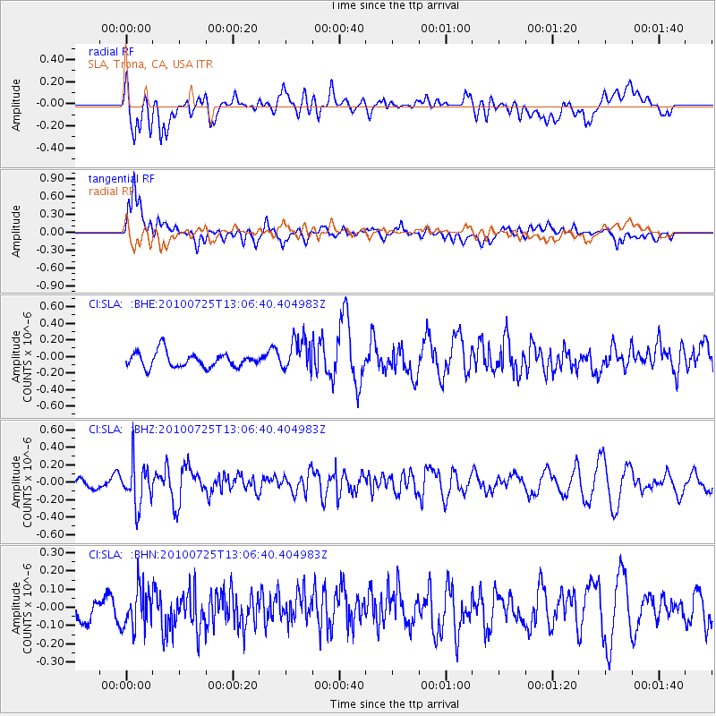
SLA SLA, Trona, CA, USA - Earthquake Result Viewer
*The percent match for this event was below the threshold and hence no stack was calculated.
| Earthquake location: |
Kuril Islands |
| Earthquake latitude/longitude: |
49.7/154.6 |
| Earthquake time(UTC): |
2010/07/25 (206) 12:57:01 GMT |
| Earthquake Depth: |
130 km |
| Earthquake Magnitude: |
5.7 MB, 5.6 MW, 5.6 MW |
| Earthquake Catalog/Contributor: |
WHDF/NEIC |
|
| Network: |
CI Caltech Regional Seismic Network |
| Station: |
SLA SLA, Trona, CA, USA |
| Lat/Lon: |
35.89 N/117.28 W |
| Elevation: |
1174 m |
|
| Distance: |
62.5 deg |
| Az: |
66.181 deg |
| Baz: |
312.988 deg |
| Ray Param: |
$rayparam |
*The percent match for this event was below the threshold and hence was not used in the summary stack. |
|
| Radial Match: |
52.07474 % |
| Radial Bump: |
400 |
| Transverse Match: |
75.09938 % |
| Transverse Bump: |
400 |
| SOD ConfigId: |
319893 |
| Insert Time: |
2011-01-05 11:36:13.781 +0000 |
| GWidth: |
2.5 |
| Max Bumps: |
400 |
| Tol: |
0.001 |
|
Signal To Noise
| Channel | StoN | STA | LTA |
| CI:SLA: :BHZ:20100725T13:06:40.404983Z | 4.121226 | 2.4256073E-7 | 5.885645E-8 |
| CI:SLA: :BHN:20100725T13:06:40.404983Z | 0.94366986 | 1.1014671E-7 | 1.1672166E-7 |
| CI:SLA: :BHE:20100725T13:06:40.404983Z | 2.2106144 | 1.9797197E-7 | 8.955518E-8 |
| Arrivals |
| Ps | |
| PpPs | |
| PsPs/PpSs | |


