You are here: Home > Network List > KN - Kyrgyz Seismic Telemetry Network Stations List
> Station TKM2 KN.TKM2 > Earthquake Result Viewer
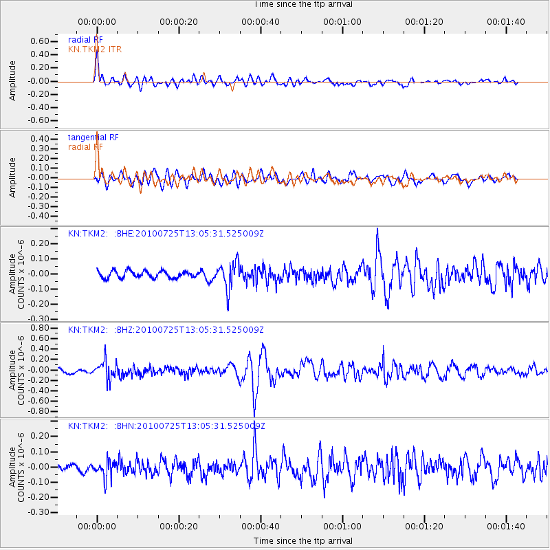
TKM2 KN.TKM2 - Earthquake Result Viewer
*The percent match for this event was below the threshold and hence no stack was calculated.
| Earthquake location: |
Kuril Islands |
| Earthquake latitude/longitude: |
49.7/154.6 |
| Earthquake time(UTC): |
2010/07/25 (206) 12:57:01 GMT |
| Earthquake Depth: |
130 km |
| Earthquake Magnitude: |
5.7 MB, 5.6 MW, 5.6 MW |
| Earthquake Catalog/Contributor: |
WHDF/NEIC |
|
| Network: |
KN Kyrgyz Seismic Telemetry Network |
| Station: |
TKM2 KN.TKM2 |
| Lat/Lon: |
42.92 N/75.60 E |
| Elevation: |
2020 m |
|
| Distance: |
52.6 deg |
| Az: |
294.873 deg |
| Baz: |
53.312 deg |
| Ray Param: |
$rayparam |
*The percent match for this event was below the threshold and hence was not used in the summary stack. |
|
| Radial Match: |
72.049 % |
| Radial Bump: |
400 |
| Transverse Match: |
61.994602 % |
| Transverse Bump: |
400 |
| SOD ConfigId: |
319893 |
| Insert Time: |
2011-01-05 11:42:50.582 +0000 |
| GWidth: |
2.5 |
| Max Bumps: |
400 |
| Tol: |
0.001 |
|
Signal To Noise
| Channel | StoN | STA | LTA |
| KN:TKM2: :BHZ:20100725T13:05:31.525009Z | 4.696532 | 1.7802428E-7 | 3.7905476E-8 |
| KN:TKM2: :BHN:20100725T13:05:31.525009Z | 2.090796 | 5.6877013E-8 | 2.7203523E-8 |
| KN:TKM2: :BHE:20100725T13:05:31.525009Z | 3.7917392 | 8.759401E-8 | 2.3101274E-8 |
| Arrivals |
| Ps | |
| PpPs | |
| PsPs/PpSs | |


