You are here: Home > Network List > LD - Lamont-Doherty Cooperative Seismographic Network Stations List
> Station MVL Millersville University, PA > Earthquake Result Viewer
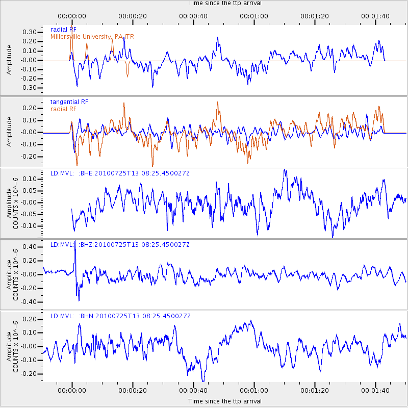
MVL Millersville University, PA - Earthquake Result Viewer
*The percent match for this event was below the threshold and hence no stack was calculated.
| Earthquake location: |
Kuril Islands |
| Earthquake latitude/longitude: |
49.7/154.6 |
| Earthquake time(UTC): |
2010/07/25 (206) 12:57:01 GMT |
| Earthquake Depth: |
130 km |
| Earthquake Magnitude: |
5.7 MB, 5.6 MW, 5.6 MW |
| Earthquake Catalog/Contributor: |
WHDF/NEIC |
|
| Network: |
LD Lamont-Doherty Cooperative Seismographic Network |
| Station: |
MVL Millersville University, PA |
| Lat/Lon: |
40.00 N/76.35 W |
| Elevation: |
91 m |
|
| Distance: |
80.0 deg |
| Az: |
37.302 deg |
| Baz: |
329.189 deg |
| Ray Param: |
$rayparam |
*The percent match for this event was below the threshold and hence was not used in the summary stack. |
|
| Radial Match: |
56.036903 % |
| Radial Bump: |
400 |
| Transverse Match: |
55.59279 % |
| Transverse Bump: |
400 |
| SOD ConfigId: |
319893 |
| Insert Time: |
2011-01-05 11:43:44.489 +0000 |
| GWidth: |
2.5 |
| Max Bumps: |
400 |
| Tol: |
0.001 |
|
Signal To Noise
| Channel | StoN | STA | LTA |
| LD:MVL: :BHZ:20100725T13:08:25.450027Z | 3.6439104 | 1.7931602E-7 | 4.9209774E-8 |
| LD:MVL: :BHN:20100725T13:08:25.450027Z | 1.1870424 | 7.0689275E-8 | 5.9550757E-8 |
| LD:MVL: :BHE:20100725T13:08:25.450027Z | 0.87684876 | 4.115581E-8 | 4.6936044E-8 |
| Arrivals |
| Ps | |
| PpPs | |
| PsPs/PpSs | |


