You are here: Home > Network List > PS - Pacific21 Stations List
> Station PSI Parapat, Indonesia > Earthquake Result Viewer
PSI Parapat, Indonesia - Earthquake Result Viewer
| Earthquake location: |
Eastern New Guinea Reg., P.N.G. |
| Earthquake latitude/longitude: |
-5.7/145.9 |
| Earthquake time(UTC): |
2023/10/07 (280) 13:10:40 GMT |
| Earthquake Depth: |
38 km |
| Earthquake Magnitude: |
5.7 mww |
| Earthquake Catalog/Contributor: |
NEIC PDE/us |
|
| Network: |
PS Pacific21 |
| Station: |
PSI Parapat, Indonesia |
| Lat/Lon: |
2.69 N/98.92 E |
| Elevation: |
987 m |
|
| Distance: |
47.6 deg |
| Az: |
278.81 deg |
| Baz: |
100.092 deg |
| Ray Param: |
0.06979386 |
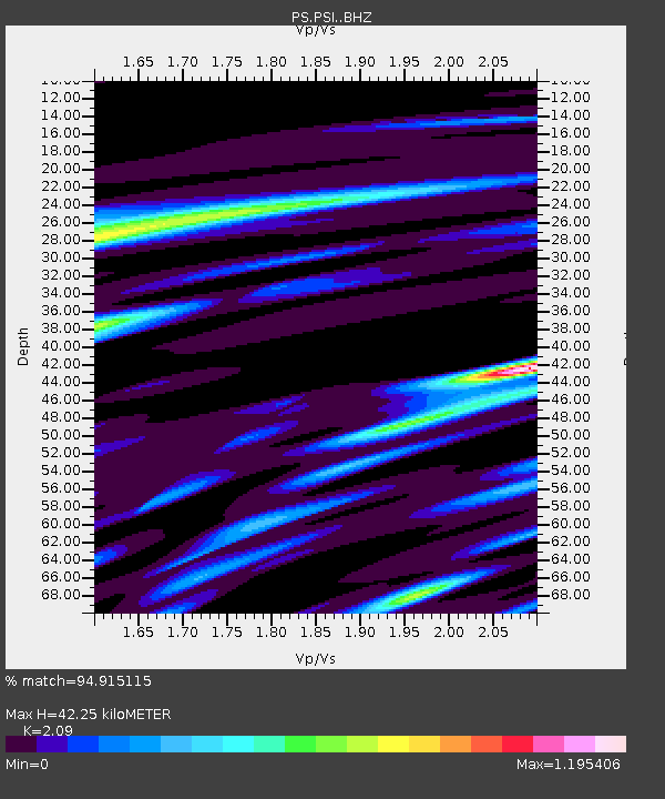
| Estimated Moho Depth: |
42.25 km |
| Estimated Crust Vp/Vs: |
2.09 |
| Assumed Crust Vp: |
6.468 km/s |
| Estimated Crust Vs: |
3.095 km/s |
| Estimated Crust Poisson's Ratio: |
0.35 |
|
| Radial Match: |
94.915115 % |
| Radial Bump: |
400 |
| Transverse Match: |
82.071365 % |
| Transverse Bump: |
400 |
| SOD ConfigId: |
31937991 |
| Insert Time: |
2023-10-21 13:37:39.104 +0000 |
| GWidth: |
2.5 |
| Max Bumps: |
400 |
| Tol: |
0.001 |
|
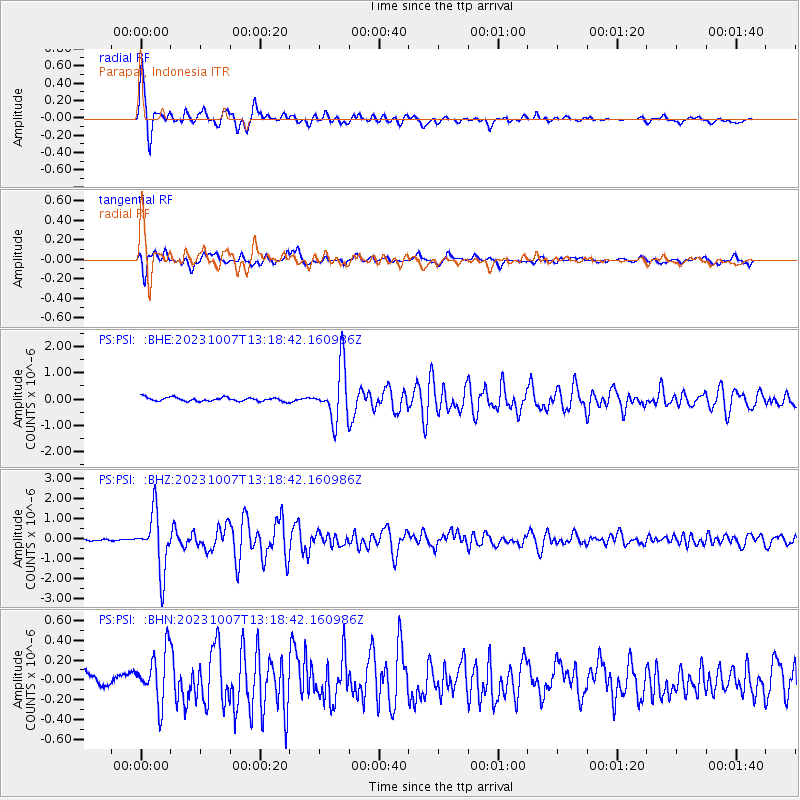
Signal To Noise
| Channel | StoN | STA | LTA |
| PS:PSI: :BHZ:20231007T13:18:42.160986Z | 25.722973 | 1.453081E-6 | 5.6489622E-8 |
| PS:PSI: :BHN:20231007T13:18:42.160986Z | 2.8015091 | 2.7780285E-7 | 9.916186E-8 |
| PS:PSI: :BHE:20231007T13:18:42.160986Z | 13.977855 | 1.018969E-6 | 7.289881E-8 |
| Arrivals |
| Ps | 7.5 SECOND |
| PpPs | 19 SECOND |
| PsPs/PpSs | 27 SECOND |


