You are here: Home > Network List > TA - USArray Transportable Network (new EarthScope stations) Stations List
> Station H20A Greybull, WY, USA > Earthquake Result Viewer
H20A Greybull, WY, USA - Earthquake Result Viewer
*The percent match for this event was below the threshold and hence no stack was calculated.
| Earthquake location: |
Kuril Islands |
| Earthquake latitude/longitude: |
49.7/154.6 |
| Earthquake time(UTC): |
2010/07/25 (206) 12:57:01 GMT |
| Earthquake Depth: |
130 km |
| Earthquake Magnitude: |
5.7 MB, 5.6 MW, 5.6 MW |
| Earthquake Catalog/Contributor: |
WHDF/NEIC |
|
| Network: |
TA USArray Transportable Network (new EarthScope stations) |
| Station: |
H20A Greybull, WY, USA |
| Lat/Lon: |
44.49 N/108.00 W |
| Elevation: |
1236 m |
|
| Distance: |
61.9 deg |
| Az: |
53.608 deg |
| Baz: |
313.096 deg |
| Ray Param: |
$rayparam |
*The percent match for this event was below the threshold and hence was not used in the summary stack. |
|
| Radial Match: |
61.642757 % |
| Radial Bump: |
400 |
| Transverse Match: |
68.961945 % |
| Transverse Bump: |
372 |
| SOD ConfigId: |
319893 |
| Insert Time: |
2011-01-05 11:48:55.558 +0000 |
| GWidth: |
2.5 |
| Max Bumps: |
400 |
| Tol: |
0.001 |
|
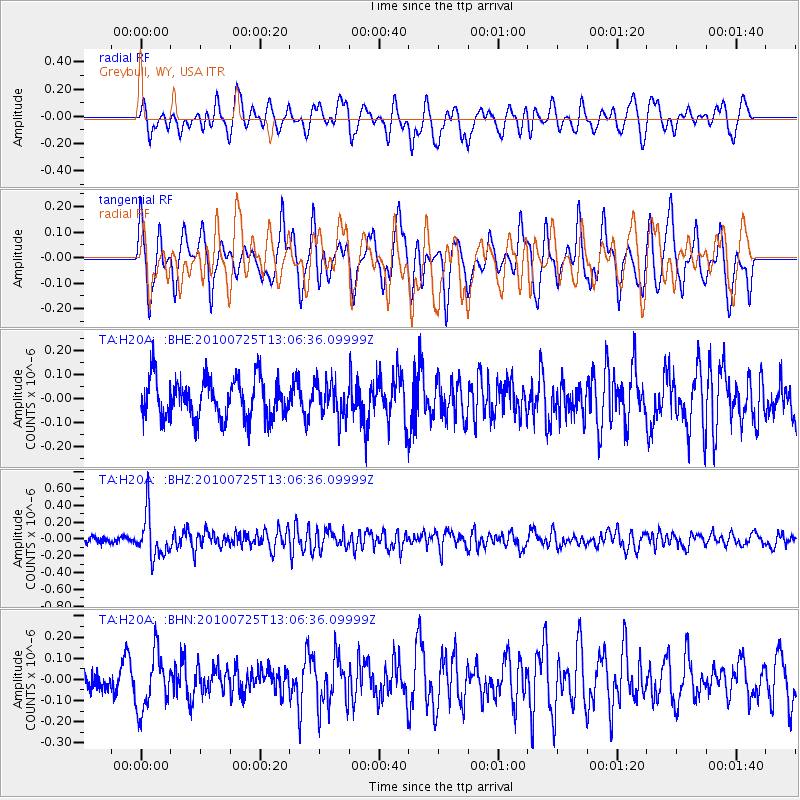
Signal To Noise
| Channel | StoN | STA | LTA |
| TA:H20A: :BHZ:20100725T13:06:36.09999Z | 5.6967316 | 2.5902034E-7 | 4.5468237E-8 |
| TA:H20A: :BHN:20100725T13:06:36.09999Z | 2.595667 | 1.3190943E-7 | 5.081909E-8 |
| TA:H20A: :BHE:20100725T13:06:36.09999Z | 0.8466772 | 6.8578984E-8 | 8.099779E-8 |
| Arrivals |
| Ps | |
| PpPs | |
| PsPs/PpSs | |


