You are here: Home > Network List > CN - Canadian National Seismograph Network Stations List
> Station INK INUVIK, NT > Earthquake Result Viewer
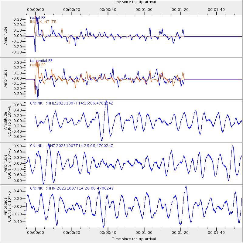
INK INUVIK, NT - Earthquake Result Viewer
*The percent match for this event was below the threshold and hence no stack was calculated.
| Earthquake location: |
Eastern New Guinea Reg., P.N.G. |
| Earthquake latitude/longitude: |
-5.6/145.9 |
| Earthquake time(UTC): |
2023/10/07 (280) 14:13:36 GMT |
| Earthquake Depth: |
62 km |
| Earthquake Magnitude: |
5.5 mb |
| Earthquake Catalog/Contributor: |
NEIC PDE/us |
|
| Network: |
CN Canadian National Seismograph Network |
| Station: |
INK INUVIK, NT |
| Lat/Lon: |
68.31 N/133.53 W |
| Elevation: |
44 m |
|
| Distance: |
91.7 deg |
| Az: |
21.527 deg |
| Baz: |
259.186 deg |
| Ray Param: |
$rayparam |
*The percent match for this event was below the threshold and hence was not used in the summary stack. |
|
| Radial Match: |
75.79964 % |
| Radial Bump: |
400 |
| Transverse Match: |
54.119354 % |
| Transverse Bump: |
400 |
| SOD ConfigId: |
31937991 |
| Insert Time: |
2023-10-21 14:27:00.043 +0000 |
| GWidth: |
2.5 |
| Max Bumps: |
400 |
| Tol: |
0.001 |
|
Signal To Noise
| Channel | StoN | STA | LTA |
| CN:INK: :HHZ:20231007T14:26:06.470024Z | 2.167924 | 5.3399407E-7 | 2.4631586E-7 |
| CN:INK: :HHN:20231007T14:26:06.470024Z | 0.56058145 | 1.6957576E-7 | 3.0249979E-7 |
| CN:INK: :HHE:20231007T14:26:06.470024Z | 1.2122582 | 1.8816424E-7 | 1.5521795E-7 |
| Arrivals |
| Ps | |
| PpPs | |
| PsPs/PpSs | |


