You are here: Home > Network List > TA - USArray Transportable Network (new EarthScope stations) Stations List
> Station F23A Volborg, MT, USA > Earthquake Result Viewer
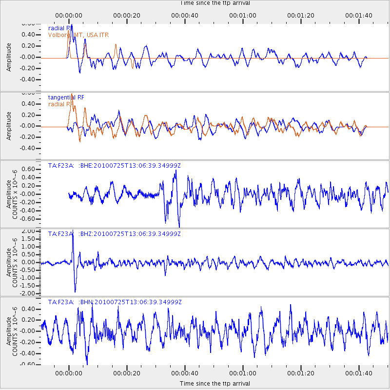
F23A Volborg, MT, USA - Earthquake Result Viewer
*The percent match for this event was below the threshold and hence no stack was calculated.
| Earthquake location: |
Kuril Islands |
| Earthquake latitude/longitude: |
49.7/154.6 |
| Earthquake time(UTC): |
2010/07/25 (206) 12:57:01 GMT |
| Earthquake Depth: |
130 km |
| Earthquake Magnitude: |
5.7 MB, 5.6 MW, 5.6 MW |
| Earthquake Catalog/Contributor: |
WHDF/NEIC |
|
| Network: |
TA USArray Transportable Network (new EarthScope stations) |
| Station: |
F23A Volborg, MT, USA |
| Lat/Lon: |
45.72 N/105.41 W |
| Elevation: |
953 m |
|
| Distance: |
62.3 deg |
| Az: |
51.166 deg |
| Baz: |
313.785 deg |
| Ray Param: |
$rayparam |
*The percent match for this event was below the threshold and hence was not used in the summary stack. |
|
| Radial Match: |
62.736584 % |
| Radial Bump: |
400 |
| Transverse Match: |
62.54239 % |
| Transverse Bump: |
400 |
| SOD ConfigId: |
319893 |
| Insert Time: |
2011-01-05 11:51:54.760 +0000 |
| GWidth: |
2.5 |
| Max Bumps: |
400 |
| Tol: |
0.001 |
|
Signal To Noise
| Channel | StoN | STA | LTA |
| TA:F23A: :BHZ:20100725T13:06:39.34999Z | 7.875342 | 7.483564E-7 | 9.5025264E-8 |
| TA:F23A: :BHN:20100725T13:06:39.34999Z | 1.9298304 | 2.4013352E-7 | 1.2443243E-7 |
| TA:F23A: :BHE:20100725T13:06:39.34999Z | 2.285287 | 2.5923643E-7 | 1.13437146E-7 |
| Arrivals |
| Ps | |
| PpPs | |
| PsPs/PpSs | |


