You are here: Home > Network List > TA - USArray Transportable Network (new EarthScope stations) Stations List
> Station 532A Rocksprings, TX, USA > Earthquake Result Viewer
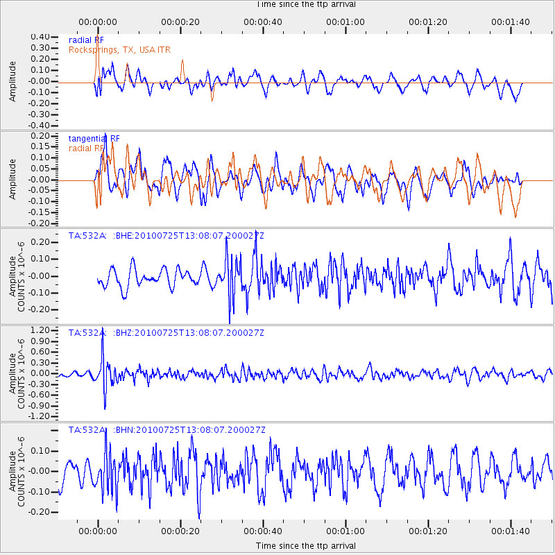
532A Rocksprings, TX, USA - Earthquake Result Viewer
*The percent match for this event was below the threshold and hence no stack was calculated.
| Earthquake location: |
Kuril Islands |
| Earthquake latitude/longitude: |
49.7/154.6 |
| Earthquake time(UTC): |
2010/07/25 (206) 12:57:01 GMT |
| Earthquake Depth: |
130 km |
| Earthquake Magnitude: |
5.7 MB, 5.6 MW, 5.6 MW |
| Earthquake Catalog/Contributor: |
WHDF/NEIC |
|
| Network: |
TA USArray Transportable Network (new EarthScope stations) |
| Station: |
532A Rocksprings, TX, USA |
| Lat/Lon: |
30.13 N/99.90 W |
| Elevation: |
703 m |
|
| Distance: |
76.7 deg |
| Az: |
59.094 deg |
| Baz: |
319.983 deg |
| Ray Param: |
$rayparam |
*The percent match for this event was below the threshold and hence was not used in the summary stack. |
|
| Radial Match: |
58.211826 % |
| Radial Bump: |
400 |
| Transverse Match: |
60.048004 % |
| Transverse Bump: |
400 |
| SOD ConfigId: |
319893 |
| Insert Time: |
2011-01-05 11:56:20.086 +0000 |
| GWidth: |
2.5 |
| Max Bumps: |
400 |
| Tol: |
0.001 |
|
Signal To Noise
| Channel | StoN | STA | LTA |
| TA:532A: :BHZ:20100725T13:08:07.200027Z | 6.1886344 | 4.1760873E-7 | 6.747995E-8 |
| TA:532A: :BHN:20100725T13:08:07.200027Z | 1.9422779 | 9.199274E-8 | 4.7363322E-8 |
| TA:532A: :BHE:20100725T13:08:07.200027Z | 2.163489 | 1.0962234E-7 | 5.0669236E-8 |
| Arrivals |
| Ps | |
| PpPs | |
| PsPs/PpSs | |


