You are here: Home > Network List > TA - USArray Transportable Network (new EarthScope stations) Stations List
> Station 232A Coleman, TX, USA > Earthquake Result Viewer
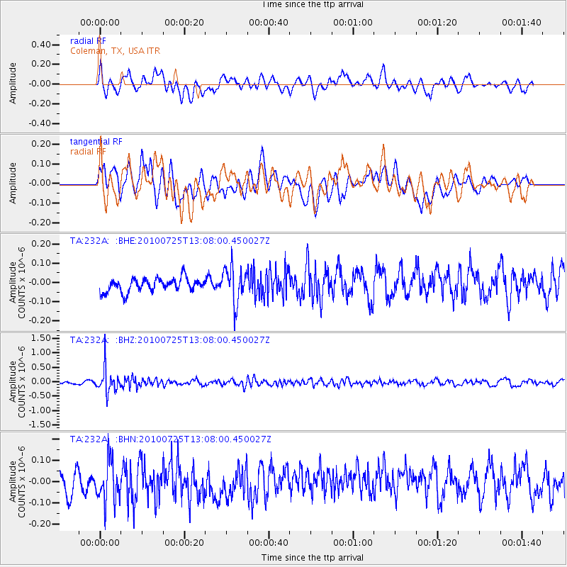
232A Coleman, TX, USA - Earthquake Result Viewer
*The percent match for this event was below the threshold and hence no stack was calculated.
| Earthquake location: |
Kuril Islands |
| Earthquake latitude/longitude: |
49.7/154.6 |
| Earthquake time(UTC): |
2010/07/25 (206) 12:57:01 GMT |
| Earthquake Depth: |
130 km |
| Earthquake Magnitude: |
5.7 MB, 5.6 MW, 5.6 MW |
| Earthquake Catalog/Contributor: |
WHDF/NEIC |
|
| Network: |
TA USArray Transportable Network (new EarthScope stations) |
| Station: |
232A Coleman, TX, USA |
| Lat/Lon: |
31.89 N/99.65 W |
| Elevation: |
621 m |
|
| Distance: |
75.5 deg |
| Az: |
57.755 deg |
| Baz: |
319.794 deg |
| Ray Param: |
$rayparam |
*The percent match for this event was below the threshold and hence was not used in the summary stack. |
|
| Radial Match: |
59.506607 % |
| Radial Bump: |
400 |
| Transverse Match: |
54.354553 % |
| Transverse Bump: |
400 |
| SOD ConfigId: |
319893 |
| Insert Time: |
2011-01-05 11:57:07.599 +0000 |
| GWidth: |
2.5 |
| Max Bumps: |
400 |
| Tol: |
0.001 |
|
Signal To Noise
| Channel | StoN | STA | LTA |
| TA:232A: :BHZ:20100725T13:08:00.450027Z | 6.140744 | 4.088822E-7 | 6.658512E-8 |
| TA:232A: :BHN:20100725T13:08:00.450027Z | 1.6927632 | 1.0163176E-7 | 6.003897E-8 |
| TA:232A: :BHE:20100725T13:08:00.450027Z | 2.6547267 | 9.350573E-8 | 3.5222357E-8 |
| Arrivals |
| Ps | |
| PpPs | |
| PsPs/PpSs | |


