You are here: Home > Network List > G - GEOSCOPE Stations List
> Station INU Inuyama, Japan > Earthquake Result Viewer
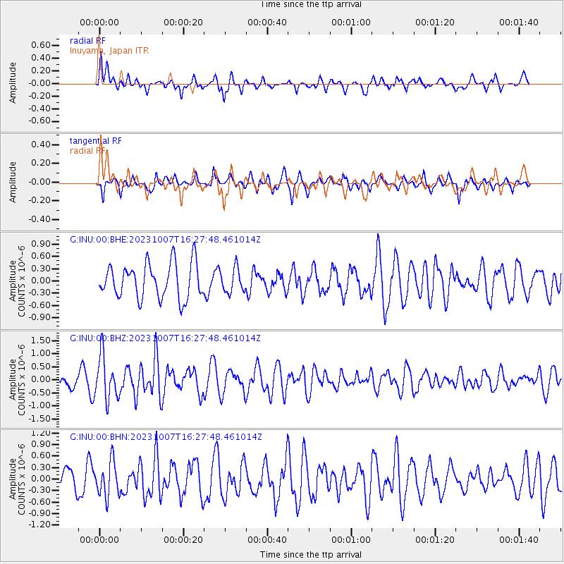
INU Inuyama, Japan - Earthquake Result Viewer
*The percent match for this event was below the threshold and hence no stack was calculated.
| Earthquake location: |
Eastern New Guinea Reg., P.N.G. |
| Earthquake latitude/longitude: |
-5.7/145.9 |
| Earthquake time(UTC): |
2023/10/07 (280) 16:20:34 GMT |
| Earthquake Depth: |
36 km |
| Earthquake Magnitude: |
5.7 mww |
| Earthquake Catalog/Contributor: |
NEIC PDE/us |
|
| Network: |
G GEOSCOPE |
| Station: |
INU Inuyama, Japan |
| Lat/Lon: |
35.35 N/137.03 E |
| Elevation: |
132 m |
|
| Distance: |
41.6 deg |
| Az: |
349.086 deg |
| Baz: |
166.673 deg |
| Ray Param: |
$rayparam |
*The percent match for this event was below the threshold and hence was not used in the summary stack. |
|
| Radial Match: |
70.146866 % |
| Radial Bump: |
400 |
| Transverse Match: |
39.714302 % |
| Transverse Bump: |
307 |
| SOD ConfigId: |
31937991 |
| Insert Time: |
2023-10-21 16:38:04.987 +0000 |
| GWidth: |
2.5 |
| Max Bumps: |
400 |
| Tol: |
0.001 |
|
Signal To Noise
| Channel | StoN | STA | LTA |
| G:INU:00:BHZ:20231007T16:27:48.461014Z | 2.60313 | 8.4326905E-7 | 3.2394428E-7 |
| G:INU:00:BHN:20231007T16:27:48.461014Z | 1.5936117 | 4.608637E-7 | 2.8919447E-7 |
| G:INU:00:BHE:20231007T16:27:48.461014Z | 0.68841994 | 2.9400746E-7 | 4.2707578E-7 |
| Arrivals |
| Ps | |
| PpPs | |
| PsPs/PpSs | |


