You are here: Home > Network List > PS - Pacific21 Stations List
> Station PSI Parapat, Indonesia > Earthquake Result Viewer
PSI Parapat, Indonesia - Earthquake Result Viewer
| Earthquake location: |
Eastern New Guinea Reg., P.N.G. |
| Earthquake latitude/longitude: |
-5.7/145.9 |
| Earthquake time(UTC): |
2023/10/07 (280) 16:20:34 GMT |
| Earthquake Depth: |
36 km |
| Earthquake Magnitude: |
5.7 mww |
| Earthquake Catalog/Contributor: |
NEIC PDE/us |
|
| Network: |
PS Pacific21 |
| Station: |
PSI Parapat, Indonesia |
| Lat/Lon: |
2.69 N/98.92 E |
| Elevation: |
987 m |
|
| Distance: |
47.6 deg |
| Az: |
278.821 deg |
| Baz: |
100.105 deg |
| Ray Param: |
0.06981204 |
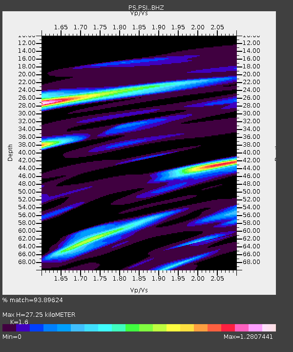
| Estimated Moho Depth: |
27.25 km |
| Estimated Crust Vp/Vs: |
1.60 |
| Assumed Crust Vp: |
6.468 km/s |
| Estimated Crust Vs: |
4.042 km/s |
| Estimated Crust Poisson's Ratio: |
0.18 |
|
| Radial Match: |
93.89624 % |
| Radial Bump: |
344 |
| Transverse Match: |
81.76862 % |
| Transverse Bump: |
400 |
| SOD ConfigId: |
31937991 |
| Insert Time: |
2023-10-21 16:44:15.913 +0000 |
| GWidth: |
2.5 |
| Max Bumps: |
400 |
| Tol: |
0.001 |
|
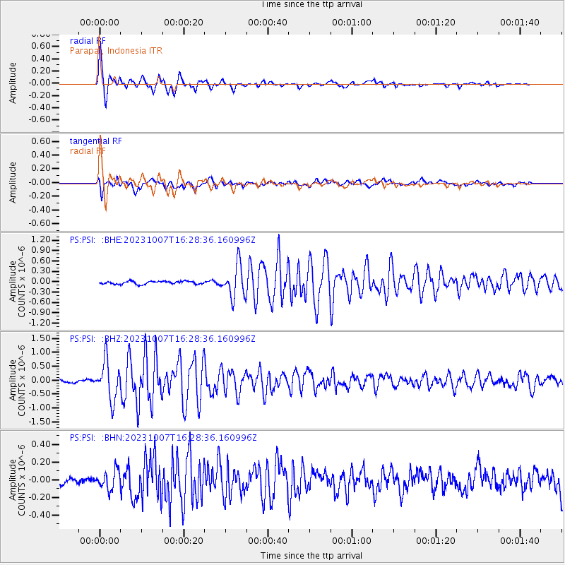
Signal To Noise
| Channel | StoN | STA | LTA |
| PS:PSI: :BHZ:20231007T16:28:36.160996Z | 14.729935 | 7.032779E-7 | 4.774481E-8 |
| PS:PSI: :BHN:20231007T16:28:36.160996Z | 2.074884 | 1.0616006E-7 | 5.1164335E-8 |
| PS:PSI: :BHE:20231007T16:28:36.160996Z | 11.283495 | 4.7872516E-7 | 4.2427025E-8 |
| Arrivals |
| Ps | 2.7 SECOND |
| PpPs | 10 SECOND |
| PsPs/PpSs | 13 SECOND |


