You are here: Home > Network List > TM - Thai Seismic Monitoring Network Stations List
> Station CHBT Khereethan Dam, Chanthaburi > Earthquake Result Viewer
CHBT Khereethan Dam, Chanthaburi - Earthquake Result Viewer
| Earthquake location: |
Eastern New Guinea Reg., P.N.G. |
| Earthquake latitude/longitude: |
-5.7/145.9 |
| Earthquake time(UTC): |
2023/10/07 (280) 16:20:34 GMT |
| Earthquake Depth: |
36 km |
| Earthquake Magnitude: |
5.7 mww |
| Earthquake Catalog/Contributor: |
NEIC PDE/us |
|
| Network: |
TM Thai Seismic Monitoring Network |
| Station: |
CHBT Khereethan Dam, Chanthaburi |
| Lat/Lon: |
12.74 N/102.35 E |
| Elevation: |
198 m |
|
| Distance: |
47.0 deg |
| Az: |
293.162 deg |
| Baz: |
110.319 deg |
| Ray Param: |
0.07023665 |
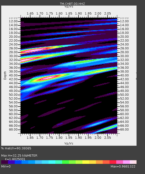
| Estimated Moho Depth: |
32.25 km |
| Estimated Crust Vp/Vs: |
1.60 |
| Assumed Crust Vp: |
6.498 km/s |
| Estimated Crust Vs: |
4.055 km/s |
| Estimated Crust Poisson's Ratio: |
0.18 |
|
| Radial Match: |
90.38065 % |
| Radial Bump: |
400 |
| Transverse Match: |
46.707912 % |
| Transverse Bump: |
400 |
| SOD ConfigId: |
31937991 |
| Insert Time: |
2023-10-21 16:45:31.559 +0000 |
| GWidth: |
2.5 |
| Max Bumps: |
400 |
| Tol: |
0.001 |
|

Signal To Noise
| Channel | StoN | STA | LTA |
| TM:CHBT:00:HHZ:20231007T16:28:30.930009Z | 7.1725383 | 5.8082315E-7 | 8.097875E-8 |
| TM:CHBT:00:HHN:20231007T16:28:30.930009Z | 2.3143928 | 3.0316062E-7 | 1.3098926E-7 |
| TM:CHBT:00:HHE:20231007T16:28:30.930009Z | 5.9600925 | 5.889556E-7 | 9.8816514E-8 |
| Arrivals |
| Ps | 3.2 SECOND |
| PpPs | 12 SECOND |
| PsPs/PpSs | 15 SECOND |


