You are here: Home > Network List > TM - Thai Seismic Monitoring Network Stations List
> Station PANO PANO staion > Earthquake Result Viewer
PANO PANO staion - Earthquake Result Viewer
| Earthquake location: |
Eastern New Guinea Reg., P.N.G. |
| Earthquake latitude/longitude: |
-5.7/145.9 |
| Earthquake time(UTC): |
2023/10/07 (280) 16:20:34 GMT |
| Earthquake Depth: |
36 km |
| Earthquake Magnitude: |
5.7 mww |
| Earthquake Catalog/Contributor: |
NEIC PDE/us |
|
| Network: |
TM Thai Seismic Monitoring Network |
| Station: |
PANO PANO staion |
| Lat/Lon: |
17.15 N/104.61 E |
| Elevation: |
136 m |
|
| Distance: |
46.7 deg |
| Az: |
299.861 deg |
| Baz: |
115.486 deg |
| Ray Param: |
0.070439965 |
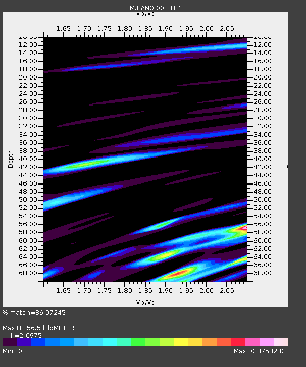
| Estimated Moho Depth: |
56.5 km |
| Estimated Crust Vp/Vs: |
2.10 |
| Assumed Crust Vp: |
6.498 km/s |
| Estimated Crust Vs: |
3.098 km/s |
| Estimated Crust Poisson's Ratio: |
0.35 |
|
| Radial Match: |
86.07245 % |
| Radial Bump: |
400 |
| Transverse Match: |
75.87505 % |
| Transverse Bump: |
400 |
| SOD ConfigId: |
31937991 |
| Insert Time: |
2023-10-21 16:45:51.871 +0000 |
| GWidth: |
2.5 |
| Max Bumps: |
400 |
| Tol: |
0.001 |
|

Signal To Noise
| Channel | StoN | STA | LTA |
| TM:PANO:00:HHZ:20231007T16:28:28.509995Z | 6.3388343 | 1.2714627E-7 | 2.0058305E-8 |
| TM:PANO:00:HHN:20231007T16:28:28.509995Z | 0.8524311 | 1.9559808E-8 | 2.294591E-8 |
| TM:PANO:00:HHE:20231007T16:28:28.509995Z | 2.290111 | 5.535414E-8 | 2.417094E-8 |
| Arrivals |
| Ps | 10 SECOND |
| PpPs | 26 SECOND |
| PsPs/PpSs | 36 SECOND |


