You are here: Home > Network List > TA - USArray Transportable Network (new EarthScope stations) Stations List
> Station H28A Mission Ridge, SD, USA > Earthquake Result Viewer
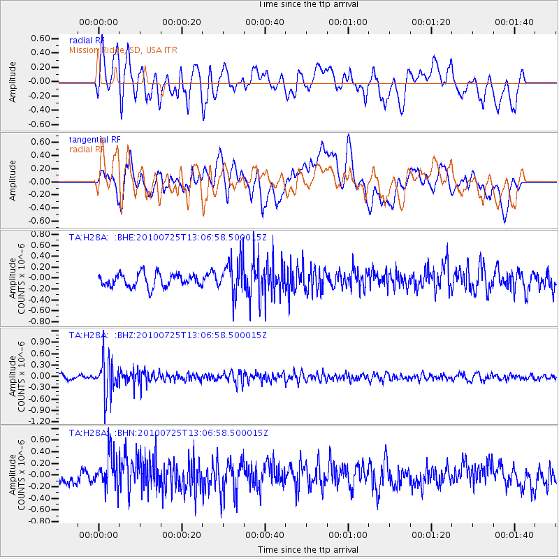
H28A Mission Ridge, SD, USA - Earthquake Result Viewer
*The percent match for this event was below the threshold and hence no stack was calculated.
| Earthquake location: |
Kuril Islands |
| Earthquake latitude/longitude: |
49.7/154.6 |
| Earthquake time(UTC): |
2010/07/25 (206) 12:57:01 GMT |
| Earthquake Depth: |
130 km |
| Earthquake Magnitude: |
5.7 MB, 5.6 MW, 5.6 MW |
| Earthquake Catalog/Contributor: |
WHDF/NEIC |
|
| Network: |
TA USArray Transportable Network (new EarthScope stations) |
| Station: |
H28A Mission Ridge, SD, USA |
| Lat/Lon: |
44.68 N/101.02 W |
| Elevation: |
642 m |
|
| Distance: |
65.3 deg |
| Az: |
49.548 deg |
| Baz: |
316.172 deg |
| Ray Param: |
$rayparam |
*The percent match for this event was below the threshold and hence was not used in the summary stack. |
|
| Radial Match: |
55.476505 % |
| Radial Bump: |
400 |
| Transverse Match: |
52.05098 % |
| Transverse Bump: |
400 |
| SOD ConfigId: |
319893 |
| Insert Time: |
2011-01-05 12:01:49.330 +0000 |
| GWidth: |
2.5 |
| Max Bumps: |
400 |
| Tol: |
0.001 |
|
Signal To Noise
| Channel | StoN | STA | LTA |
| TA:H28A: :BHZ:20100725T13:06:58.500015Z | 11.136406 | 4.848256E-7 | 4.3535195E-8 |
| TA:H28A: :BHN:20100725T13:06:58.500015Z | 3.605959 | 3.1531096E-7 | 8.744164E-8 |
| TA:H28A: :BHE:20100725T13:06:58.500015Z | 2.926213 | 3.4830967E-7 | 1.19030865E-7 |
| Arrivals |
| Ps | |
| PpPs | |
| PsPs/PpSs | |


