You are here: Home > Network List > IU - Global Seismograph Network (GSN - IRIS/USGS) Stations List
> Station MAKZ Makanchi, Kazakhstan > Earthquake Result Viewer
MAKZ Makanchi, Kazakhstan - Earthquake Result Viewer
| Earthquake location: |
Aru Islands Region, Indonesia |
| Earthquake latitude/longitude: |
-5.5/133.8 |
| Earthquake time(UTC): |
2019/01/26 (026) 08:12:48 GMT |
| Earthquake Depth: |
10 km |
| Earthquake Magnitude: |
5.8 Mww |
| Earthquake Catalog/Contributor: |
NEIC PDE/us |
|
| Network: |
IU Global Seismograph Network (GSN - IRIS/USGS) |
| Station: |
MAKZ Makanchi, Kazakhstan |
| Lat/Lon: |
46.81 N/81.98 E |
| Elevation: |
600 m |
|
| Distance: |
69.3 deg |
| Az: |
324.756 deg |
| Baz: |
123.248 deg |
| Ray Param: |
0.055757318 |
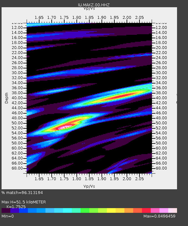
| Estimated Moho Depth: |
51.5 km |
| Estimated Crust Vp/Vs: |
1.75 |
| Assumed Crust Vp: |
6.571 km/s |
| Estimated Crust Vs: |
3.749 km/s |
| Estimated Crust Poisson's Ratio: |
0.26 |
|
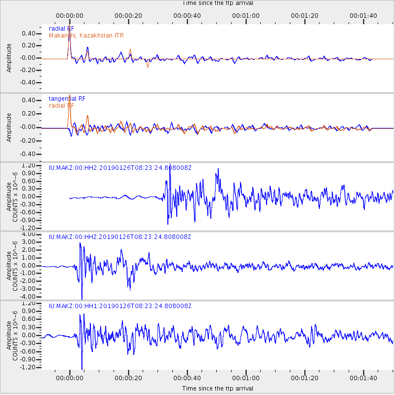
| Radial Match: |
96.313194 % |
| Radial Bump: |
344 |
| Transverse Match: |
83.1455 % |
| Transverse Bump: |
400 |
| SOD ConfigId: |
3276131 |
| Insert Time: |
2019-02-09 08:23:13.556 +0000 |
| GWidth: |
2.5 |
| Max Bumps: |
400 |
| Tol: |
0.001 |
|
Signal To Noise
| Channel | StoN | STA | LTA |
| IU:MAKZ:00:HHZ:20190126T08:23:24.808008Z | 22.18413 | 1.3670101E-6 | 6.162108E-8 |
| IU:MAKZ:00:HH1:20190126T08:23:24.808008Z | 10.407773 | 3.4482233E-7 | 3.313123E-8 |
| IU:MAKZ:00:HH2:20190126T08:23:24.808008Z | 13.881849 | 4.2637822E-7 | 3.07148E-8 |
| Arrivals |
| Ps | 6.1 SECOND |
| PpPs | 21 SECOND |
| PsPs/PpSs | 27 SECOND |


