You are here: Home > Network List > TA - USArray Transportable Network (new EarthScope stations) Stations List
> Station D30A Buchanan, ND, USA > Earthquake Result Viewer
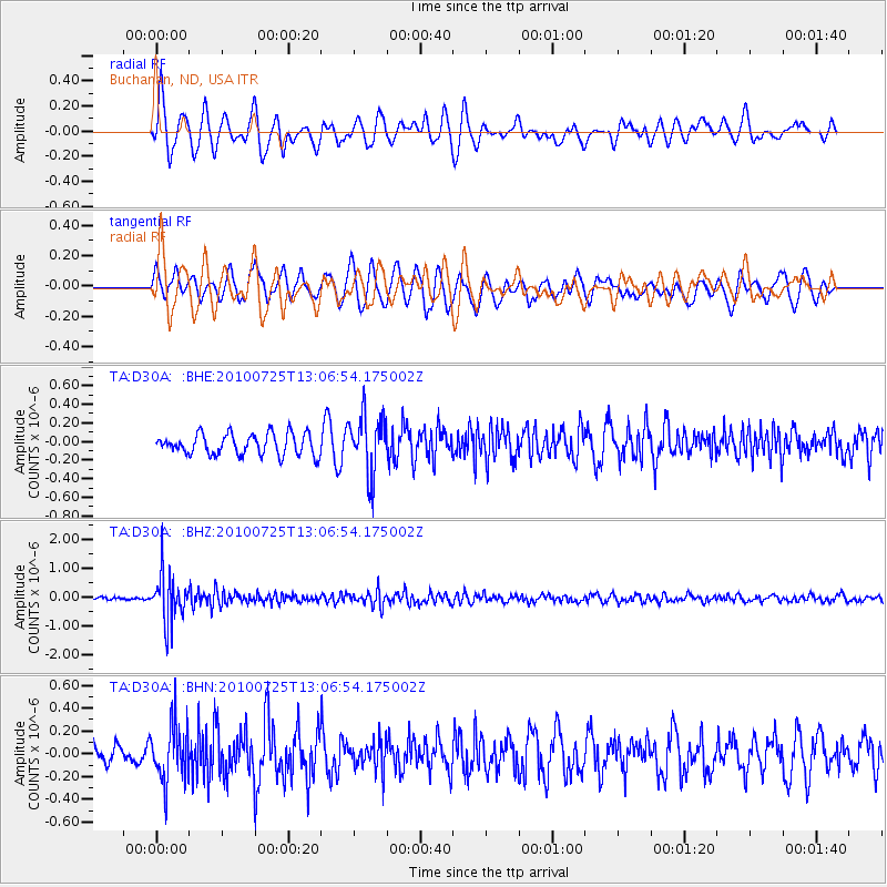
D30A Buchanan, ND, USA - Earthquake Result Viewer
*The percent match for this event was below the threshold and hence no stack was calculated.
| Earthquake location: |
Kuril Islands |
| Earthquake latitude/longitude: |
49.7/154.6 |
| Earthquake time(UTC): |
2010/07/25 (206) 12:57:01 GMT |
| Earthquake Depth: |
130 km |
| Earthquake Magnitude: |
5.7 MB, 5.6 MW, 5.6 MW |
| Earthquake Catalog/Contributor: |
WHDF/NEIC |
|
| Network: |
TA USArray Transportable Network (new EarthScope stations) |
| Station: |
D30A Buchanan, ND, USA |
| Lat/Lon: |
47.11 N/98.76 W |
| Elevation: |
465 m |
|
| Distance: |
64.6 deg |
| Az: |
46.431 deg |
| Baz: |
316.472 deg |
| Ray Param: |
$rayparam |
*The percent match for this event was below the threshold and hence was not used in the summary stack. |
|
| Radial Match: |
62.51717 % |
| Radial Bump: |
400 |
| Transverse Match: |
49.38244 % |
| Transverse Bump: |
396 |
| SOD ConfigId: |
319893 |
| Insert Time: |
2011-01-05 12:03:52.071 +0000 |
| GWidth: |
2.5 |
| Max Bumps: |
400 |
| Tol: |
0.001 |
|
Signal To Noise
| Channel | StoN | STA | LTA |
| TA:D30A: :BHZ:20100725T13:06:54.175002Z | 14.173665 | 8.295065E-7 | 5.852449E-8 |
| TA:D30A: :BHN:20100725T13:06:54.175002Z | 2.6204703 | 2.5522695E-7 | 9.739738E-8 |
| TA:D30A: :BHE:20100725T13:06:54.175002Z | 2.8158736 | 3.1856231E-7 | 1.131309E-7 |
| Arrivals |
| Ps | |
| PpPs | |
| PsPs/PpSs | |


