You are here: Home > Network List > TA - USArray Transportable Network (new EarthScope stations) Stations List
> Station E29A Napoleon, ND, USA > Earthquake Result Viewer
E29A Napoleon, ND, USA - Earthquake Result Viewer
*The percent match for this event was below the threshold and hence no stack was calculated.
| Earthquake location: |
Kuril Islands |
| Earthquake latitude/longitude: |
49.7/154.6 |
| Earthquake time(UTC): |
2010/07/25 (206) 12:57:01 GMT |
| Earthquake Depth: |
130 km |
| Earthquake Magnitude: |
5.7 MB, 5.6 MW, 5.6 MW |
| Earthquake Catalog/Contributor: |
WHDF/NEIC |
|
| Network: |
TA USArray Transportable Network (new EarthScope stations) |
| Station: |
E29A Napoleon, ND, USA |
| Lat/Lon: |
46.57 N/99.64 W |
| Elevation: |
628 m |
|
| Distance: |
64.6 deg |
| Az: |
47.33 deg |
| Baz: |
316.215 deg |
| Ray Param: |
$rayparam |
*The percent match for this event was below the threshold and hence was not used in the summary stack. |
|
| Radial Match: |
34.88453 % |
| Radial Bump: |
400 |
| Transverse Match: |
66.92762 % |
| Transverse Bump: |
400 |
| SOD ConfigId: |
319893 |
| Insert Time: |
2011-01-05 12:04:43.600 +0000 |
| GWidth: |
2.5 |
| Max Bumps: |
400 |
| Tol: |
0.001 |
|
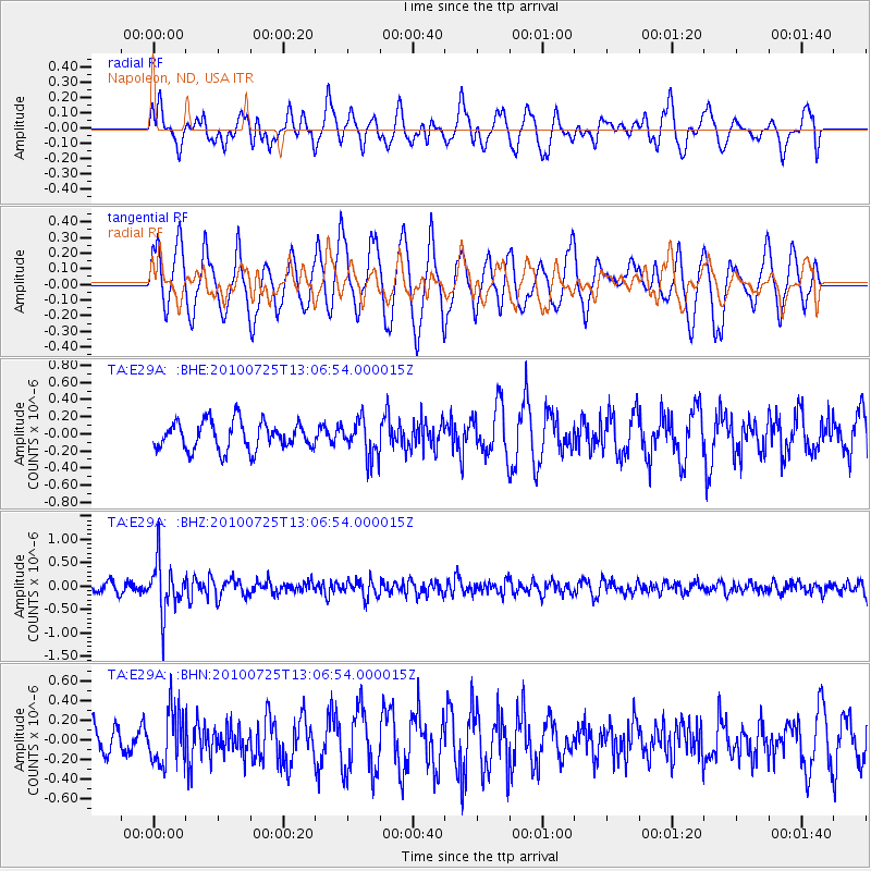
Signal To Noise
| Channel | StoN | STA | LTA |
| TA:E29A: :BHZ:20100725T13:06:54.000015Z | 5.9979305 | 5.4106494E-7 | 9.0208594E-8 |
| TA:E29A: :BHN:20100725T13:06:54.000015Z | 1.1780615 | 2.7544024E-7 | 2.3380805E-7 |
| TA:E29A: :BHE:20100725T13:06:54.000015Z | 1.3186443 | 2.1473276E-7 | 1.6284359E-7 |
| Arrivals |
| Ps | |
| PpPs | |
| PsPs/PpSs | |


