You are here: Home > Network List > TA - USArray Transportable Network (new EarthScope stations) Stations List
> Station A30A Hoffart Farm, Langdon, ND, USA > Earthquake Result Viewer
A30A Hoffart Farm, Langdon, ND, USA - Earthquake Result Viewer

| Earthquake location: |
Kuril Islands |
| Earthquake latitude/longitude: |
49.7/154.6 |
| Earthquake time(UTC): |
2010/07/25 (206) 12:57:01 GMT |
| Earthquake Depth: |
130 km |
| Earthquake Magnitude: |
5.7 MB, 5.6 MW, 5.6 MW |
| Earthquake Catalog/Contributor: |
WHDF/NEIC |
|
| Network: |
TA USArray Transportable Network (new EarthScope stations) |
| Station: |
A30A Hoffart Farm, Langdon, ND, USA |
| Lat/Lon: |
48.94 N/98.30 W |
| Elevation: |
484 m |
|
| Distance: |
63.5 deg |
| Az: |
44.776 deg |
| Baz: |
316.087 deg |
| Ray Param: |
0.059164446 |
| Estimated Moho Depth: |
23.25 km |
| Estimated Crust Vp/Vs: |
1.73 |
| Assumed Crust Vp: |
6.53 km/s |
| Estimated Crust Vs: |
3.775 km/s |
| Estimated Crust Poisson's Ratio: |
0.25 |
|
| Radial Match: |
86.61082 % |
| Radial Bump: |
400 |
| Transverse Match: |
73.43966 % |
| Transverse Bump: |
400 |
| SOD ConfigId: |
319893 |
| Insert Time: |
2011-01-05 12:04:59.494 +0000 |
| GWidth: |
2.5 |
| Max Bumps: |
400 |
| Tol: |
0.001 |
|
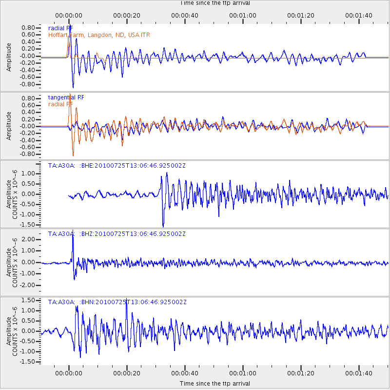
Signal To Noise
| Channel | StoN | STA | LTA |
| TA:A30A: :BHZ:20100725T13:06:46.925002Z | 16.545612 | 7.640032E-7 | 4.6175575E-8 |
| TA:A30A: :BHN:20100725T13:06:46.925002Z | 6.871937 | 6.552748E-7 | 9.535518E-8 |
| TA:A30A: :BHE:20100725T13:06:46.925002Z | 6.5645275 | 6.3047764E-7 | 9.604312E-8 |
| Arrivals |
| Ps | 2.7 SECOND |
| PpPs | 9.3 SECOND |
| PsPs/PpSs | 12 SECOND |


