You are here: Home > Network List > TA - USArray Transportable Network (new EarthScope stations) Stations List
> Station TOLK Toolik Lake Research Station, AK, USA > Earthquake Result Viewer
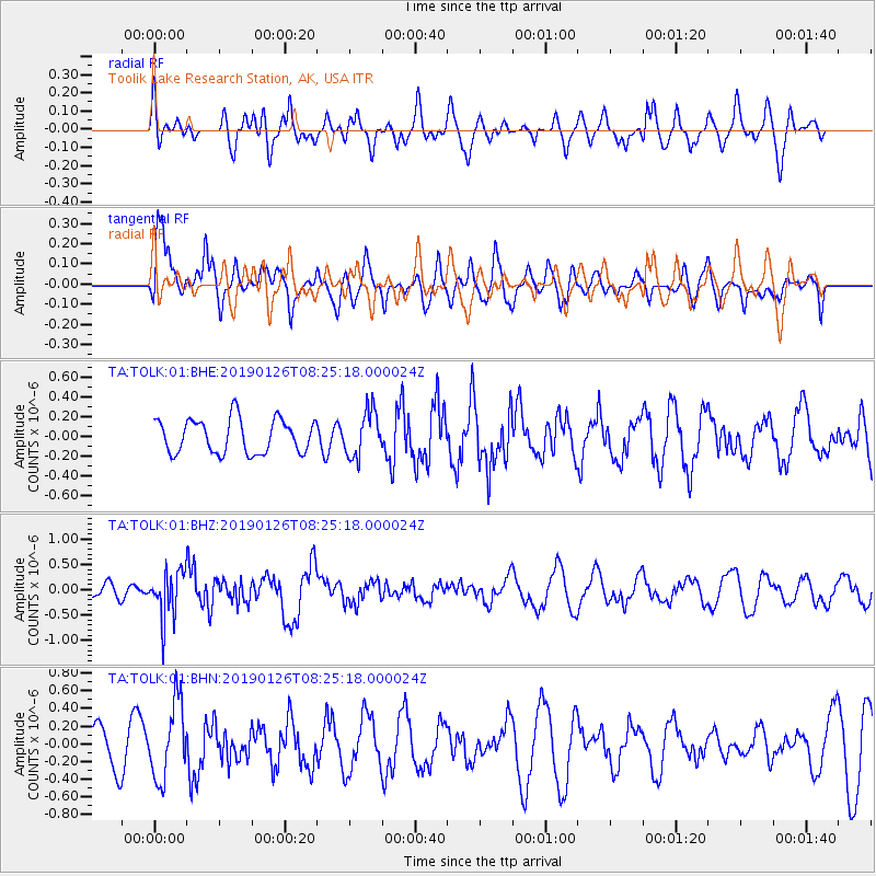
TOLK Toolik Lake Research Station, AK, USA - Earthquake Result Viewer
*The percent match for this event was below the threshold and hence no stack was calculated.
| Earthquake location: |
Aru Islands Region, Indonesia |
| Earthquake latitude/longitude: |
-5.5/133.8 |
| Earthquake time(UTC): |
2019/01/26 (026) 08:12:48 GMT |
| Earthquake Depth: |
10 km |
| Earthquake Magnitude: |
5.8 Mww |
| Earthquake Catalog/Contributor: |
NEIC PDE/us |
|
| Network: |
TA USArray Transportable Network (new EarthScope stations) |
| Station: |
TOLK Toolik Lake Research Station, AK, USA |
| Lat/Lon: |
68.64 N/149.57 W |
| Elevation: |
760 m |
|
| Distance: |
90.2 deg |
| Az: |
20.883 deg |
| Baz: |
255.612 deg |
| Ray Param: |
$rayparam |
*The percent match for this event was below the threshold and hence was not used in the summary stack. |
|
| Radial Match: |
49.649017 % |
| Radial Bump: |
400 |
| Transverse Match: |
60.52877 % |
| Transverse Bump: |
400 |
| SOD ConfigId: |
3276131 |
| Insert Time: |
2019-02-09 08:24:11.889 +0000 |
| GWidth: |
2.5 |
| Max Bumps: |
400 |
| Tol: |
0.001 |
|
Signal To Noise
| Channel | StoN | STA | LTA |
| TA:TOLK:01:BHZ:20190126T08:25:18.000024Z | 4.2470713 | 4.5461303E-7 | 1.0704154E-7 |
| TA:TOLK:01:BHN:20190126T08:25:18.000024Z | 2.3657377 | 4.2816998E-7 | 1.8098793E-7 |
| TA:TOLK:01:BHE:20190126T08:25:18.000024Z | 1.3560358 | 2.3094512E-7 | 1.7030901E-7 |
| Arrivals |
| Ps | |
| PpPs | |
| PsPs/PpSs | |


