You are here: Home > Network List > TA - USArray Transportable Network (new EarthScope stations) Stations List
> Station K30A Basset, NE, USA > Earthquake Result Viewer
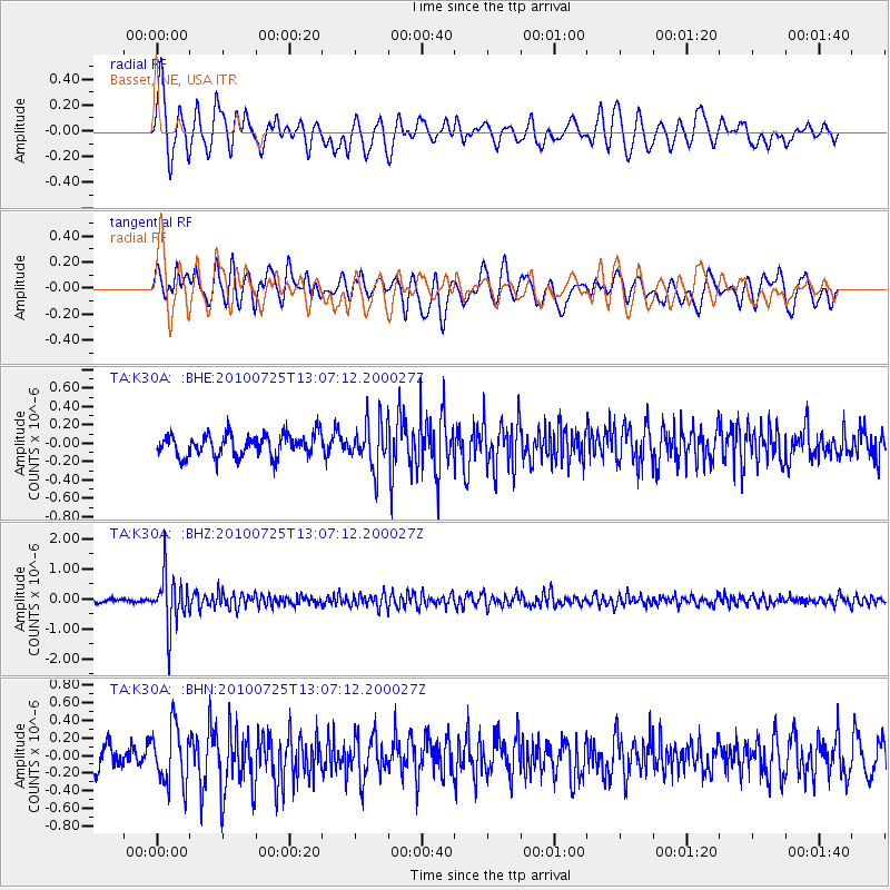
K30A Basset, NE, USA - Earthquake Result Viewer
*The percent match for this event was below the threshold and hence no stack was calculated.
| Earthquake location: |
Kuril Islands |
| Earthquake latitude/longitude: |
49.7/154.6 |
| Earthquake time(UTC): |
2010/07/25 (206) 12:57:01 GMT |
| Earthquake Depth: |
130 km |
| Earthquake Magnitude: |
5.7 MB, 5.6 MW, 5.6 MW |
| Earthquake Catalog/Contributor: |
WHDF/NEIC |
|
| Network: |
TA USArray Transportable Network (new EarthScope stations) |
| Station: |
K30A Basset, NE, USA |
| Lat/Lon: |
42.67 N/99.61 W |
| Elevation: |
712 m |
|
| Distance: |
67.4 deg |
| Az: |
50.23 deg |
| Baz: |
317.415 deg |
| Ray Param: |
$rayparam |
*The percent match for this event was below the threshold and hence was not used in the summary stack. |
|
| Radial Match: |
69.6086 % |
| Radial Bump: |
400 |
| Transverse Match: |
71.17018 % |
| Transverse Bump: |
400 |
| SOD ConfigId: |
319893 |
| Insert Time: |
2011-01-05 12:07:38.397 +0000 |
| GWidth: |
2.5 |
| Max Bumps: |
400 |
| Tol: |
0.001 |
|
Signal To Noise
| Channel | StoN | STA | LTA |
| TA:K30A: :BHZ:20100725T13:07:12.200027Z | 12.382068 | 8.4297545E-7 | 6.808035E-8 |
| TA:K30A: :BHN:20100725T13:07:12.200027Z | 2.3181002 | 3.2691122E-7 | 1.410255E-7 |
| TA:K30A: :BHE:20100725T13:07:12.200027Z | 2.05045 | 2.4659437E-7 | 1.2026352E-7 |
| Arrivals |
| Ps | |
| PpPs | |
| PsPs/PpSs | |


