You are here: Home > Network List > TA - USArray Transportable Network (new EarthScope stations) Stations List
> Station J05D Fort Rock, OR, USA > Earthquake Result Viewer
J05D Fort Rock, OR, USA - Earthquake Result Viewer
*The percent match for this event was below the threshold and hence no stack was calculated.
| Earthquake location: |
Kuril Islands |
| Earthquake latitude/longitude: |
49.7/154.6 |
| Earthquake time(UTC): |
2010/07/25 (206) 12:57:01 GMT |
| Earthquake Depth: |
130 km |
| Earthquake Magnitude: |
5.7 MB, 5.6 MW, 5.6 MW |
| Earthquake Catalog/Contributor: |
WHDF/NEIC |
|
| Network: |
TA USArray Transportable Network (new EarthScope stations) |
| Station: |
J05D Fort Rock, OR, USA |
| Lat/Lon: |
43.28 N/121.23 W |
| Elevation: |
1541 m |
|
| Distance: |
55.4 deg |
| Az: |
61.969 deg |
| Baz: |
308.297 deg |
| Ray Param: |
$rayparam |
*The percent match for this event was below the threshold and hence was not used in the summary stack. |
|
| Radial Match: |
51.03394 % |
| Radial Bump: |
400 |
| Transverse Match: |
39.22755 % |
| Transverse Bump: |
400 |
| SOD ConfigId: |
319893 |
| Insert Time: |
2011-01-05 12:08:17.810 +0000 |
| GWidth: |
2.5 |
| Max Bumps: |
400 |
| Tol: |
0.001 |
|
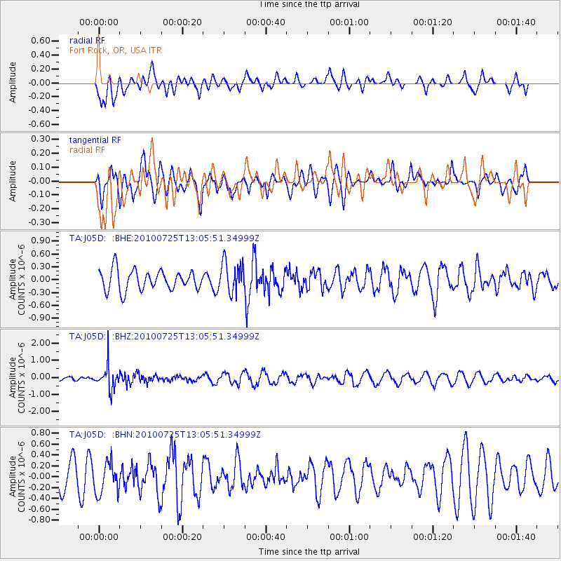
Signal To Noise
| Channel | StoN | STA | LTA |
| TA:J05D: :BHZ:20100725T13:05:51.34999Z | 3.257334 | 6.907627E-7 | 2.1206382E-7 |
| TA:J05D: :BHN:20100725T13:05:51.34999Z | 0.9911002 | 2.9890876E-7 | 3.0159288E-7 |
| TA:J05D: :BHE:20100725T13:05:51.34999Z | 1.5616791 | 3.6519754E-7 | 2.3384928E-7 |
| Arrivals |
| Ps | |
| PpPs | |
| PsPs/PpSs | |


