You are here: Home > Network List > TA - USArray Transportable Network (new EarthScope stations) Stations List
> Station 340A Bronson, TX, USA > Earthquake Result Viewer
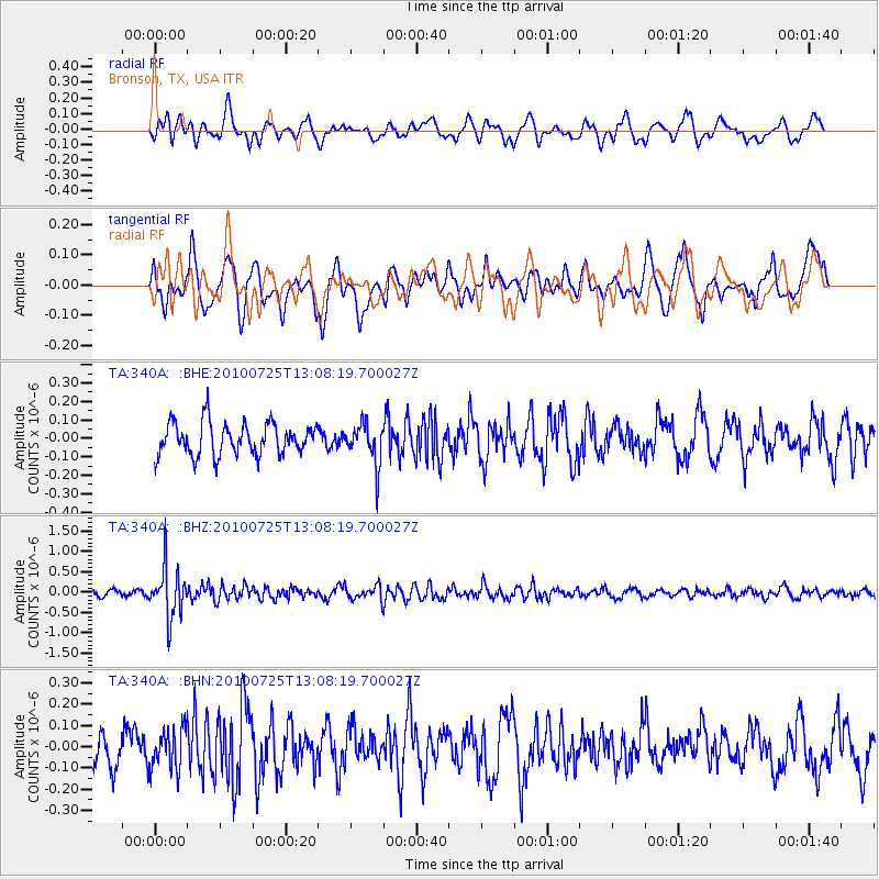
340A Bronson, TX, USA - Earthquake Result Viewer
*The percent match for this event was below the threshold and hence no stack was calculated.
| Earthquake location: |
Kuril Islands |
| Earthquake latitude/longitude: |
49.7/154.6 |
| Earthquake time(UTC): |
2010/07/25 (206) 12:57:01 GMT |
| Earthquake Depth: |
130 km |
| Earthquake Magnitude: |
5.7 MB, 5.6 MW, 5.6 MW |
| Earthquake Catalog/Contributor: |
WHDF/NEIC |
|
| Network: |
TA USArray Transportable Network (new EarthScope stations) |
| Station: |
340A Bronson, TX, USA |
| Lat/Lon: |
31.42 N/93.89 W |
| Elevation: |
57 m |
|
| Distance: |
79.0 deg |
| Az: |
54.152 deg |
| Baz: |
322.006 deg |
| Ray Param: |
$rayparam |
*The percent match for this event was below the threshold and hence was not used in the summary stack. |
|
| Radial Match: |
48.261997 % |
| Radial Bump: |
400 |
| Transverse Match: |
56.302116 % |
| Transverse Bump: |
400 |
| SOD ConfigId: |
319893 |
| Insert Time: |
2011-01-05 12:13:56.662 +0000 |
| GWidth: |
2.5 |
| Max Bumps: |
400 |
| Tol: |
0.001 |
|
Signal To Noise
| Channel | StoN | STA | LTA |
| TA:340A: :BHZ:20100725T13:08:19.700027Z | 7.204016 | 6.2374215E-7 | 8.658255E-8 |
| TA:340A: :BHN:20100725T13:08:19.700027Z | 0.9761072 | 9.676124E-8 | 9.912973E-8 |
| TA:340A: :BHE:20100725T13:08:19.700027Z | 1.2814335 | 1.10112204E-7 | 8.5928924E-8 |
| Arrivals |
| Ps | |
| PpPs | |
| PsPs/PpSs | |


