You are here: Home > Network List > TA - USArray Transportable Network (new EarthScope stations) Stations List
> Station 239A Gary, TX, USA > Earthquake Result Viewer
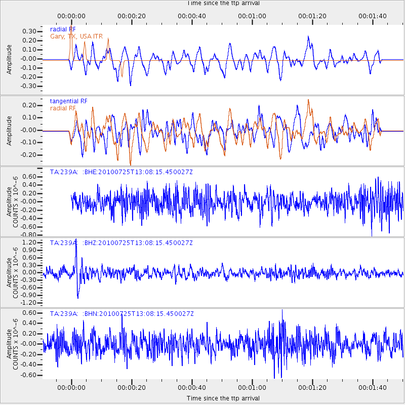
239A Gary, TX, USA - Earthquake Result Viewer
*The percent match for this event was below the threshold and hence no stack was calculated.
| Earthquake location: |
Kuril Islands |
| Earthquake latitude/longitude: |
49.7/154.6 |
| Earthquake time(UTC): |
2010/07/25 (206) 12:57:01 GMT |
| Earthquake Depth: |
130 km |
| Earthquake Magnitude: |
5.7 MB, 5.6 MW, 5.6 MW |
| Earthquake Catalog/Contributor: |
WHDF/NEIC |
|
| Network: |
TA USArray Transportable Network (new EarthScope stations) |
| Station: |
239A Gary, TX, USA |
| Lat/Lon: |
32.02 N/94.47 W |
| Elevation: |
100 m |
|
| Distance: |
78.2 deg |
| Az: |
54.172 deg |
| Baz: |
321.706 deg |
| Ray Param: |
$rayparam |
*The percent match for this event was below the threshold and hence was not used in the summary stack. |
|
| Radial Match: |
57.493725 % |
| Radial Bump: |
400 |
| Transverse Match: |
59.36356 % |
| Transverse Bump: |
400 |
| SOD ConfigId: |
319893 |
| Insert Time: |
2011-01-05 12:14:09.411 +0000 |
| GWidth: |
2.5 |
| Max Bumps: |
400 |
| Tol: |
0.001 |
|
Signal To Noise
| Channel | StoN | STA | LTA |
| TA:239A: :BHZ:20100725T13:08:15.450027Z | 4.712401 | 4.814735E-7 | 1.0217158E-7 |
| TA:239A: :BHN:20100725T13:08:15.450027Z | 1.0909069 | 1.701792E-7 | 1.5599794E-7 |
| TA:239A: :BHE:20100725T13:08:15.450027Z | 1.2299987 | 2.2054004E-7 | 1.7930104E-7 |
| Arrivals |
| Ps | |
| PpPs | |
| PsPs/PpSs | |


