You are here: Home > Network List > TA - USArray Transportable Network (new EarthScope stations) Stations List
> Station 137A Heron Place, Grans Saline, TX, USA > Earthquake Result Viewer
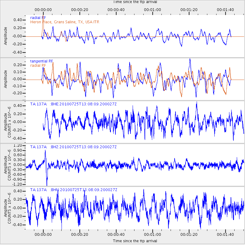
137A Heron Place, Grans Saline, TX, USA - Earthquake Result Viewer
*The percent match for this event was below the threshold and hence no stack was calculated.
| Earthquake location: |
Kuril Islands |
| Earthquake latitude/longitude: |
49.7/154.6 |
| Earthquake time(UTC): |
2010/07/25 (206) 12:57:01 GMT |
| Earthquake Depth: |
130 km |
| Earthquake Magnitude: |
5.7 MB, 5.6 MW, 5.6 MW |
| Earthquake Catalog/Contributor: |
WHDF/NEIC |
|
| Network: |
TA USArray Transportable Network (new EarthScope stations) |
| Station: |
137A Heron Place, Grans Saline, TX, USA |
| Lat/Lon: |
32.60 N/95.76 W |
| Elevation: |
141 m |
|
| Distance: |
77.1 deg |
| Az: |
54.674 deg |
| Baz: |
321.13 deg |
| Ray Param: |
$rayparam |
*The percent match for this event was below the threshold and hence was not used in the summary stack. |
|
| Radial Match: |
56.18077 % |
| Radial Bump: |
400 |
| Transverse Match: |
67.20619 % |
| Transverse Bump: |
369 |
| SOD ConfigId: |
319893 |
| Insert Time: |
2011-01-05 12:14:23.781 +0000 |
| GWidth: |
2.5 |
| Max Bumps: |
400 |
| Tol: |
0.001 |
|
Signal To Noise
| Channel | StoN | STA | LTA |
| TA:137A: :BHZ:20100725T13:08:09.200027Z | 3.5866015 | 4.3073973E-7 | 1.2009691E-7 |
| TA:137A: :BHN:20100725T13:08:09.200027Z | 1.1650186 | 1.4235043E-7 | 1.2218727E-7 |
| TA:137A: :BHE:20100725T13:08:09.200027Z | 0.6317093 | 8.9753485E-8 | 1.4208037E-7 |
| Arrivals |
| Ps | |
| PpPs | |
| PsPs/PpSs | |


