You are here: Home > Network List > TA - USArray Transportable Network (new EarthScope stations) Stations List
> Station X36A Centrahoma, OK, USA > Earthquake Result Viewer
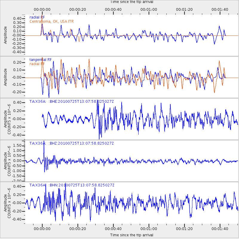
X36A Centrahoma, OK, USA - Earthquake Result Viewer
*The percent match for this event was below the threshold and hence no stack was calculated.
| Earthquake location: |
Kuril Islands |
| Earthquake latitude/longitude: |
49.7/154.6 |
| Earthquake time(UTC): |
2010/07/25 (206) 12:57:01 GMT |
| Earthquake Depth: |
130 km |
| Earthquake Magnitude: |
5.7 MB, 5.6 MW, 5.6 MW |
| Earthquake Catalog/Contributor: |
WHDF/NEIC |
|
| Network: |
TA USArray Transportable Network (new EarthScope stations) |
| Station: |
X36A Centrahoma, OK, USA |
| Lat/Lon: |
34.57 N/96.35 W |
| Elevation: |
211 m |
|
| Distance: |
75.2 deg |
| Az: |
53.792 deg |
| Baz: |
320.591 deg |
| Ray Param: |
$rayparam |
*The percent match for this event was below the threshold and hence was not used in the summary stack. |
|
| Radial Match: |
58.05561 % |
| Radial Bump: |
400 |
| Transverse Match: |
56.00749 % |
| Transverse Bump: |
400 |
| SOD ConfigId: |
319893 |
| Insert Time: |
2011-01-05 12:15:40.133 +0000 |
| GWidth: |
2.5 |
| Max Bumps: |
400 |
| Tol: |
0.001 |
|
Signal To Noise
| Channel | StoN | STA | LTA |
| TA:X36A: :BHZ:20100725T13:07:58.825027Z | 6.1733994 | 5.300212E-7 | 8.585565E-8 |
| TA:X36A: :BHN:20100725T13:07:58.825027Z | 1.9907796 | 1.7132635E-7 | 8.605993E-8 |
| TA:X36A: :BHE:20100725T13:07:58.825027Z | 3.2108798 | 2.4169142E-7 | 7.5272645E-8 |
| Arrivals |
| Ps | |
| PpPs | |
| PsPs/PpSs | |


