You are here: Home > Network List > TA - USArray Transportable Network (new EarthScope stations) Stations List
> Station Y35A Marietta, OK, USA > Earthquake Result Viewer
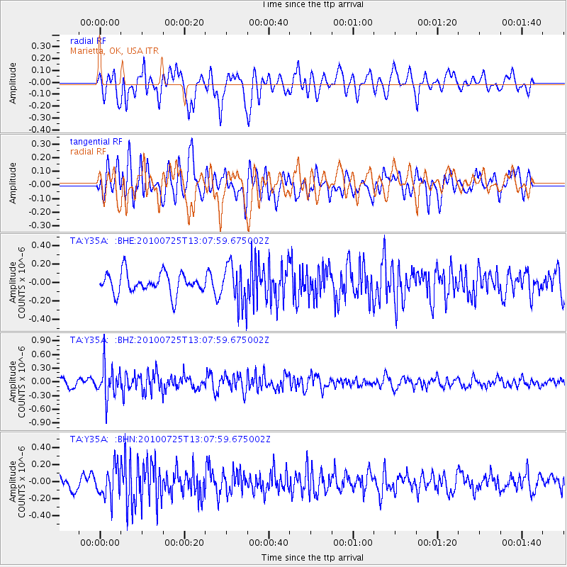
Y35A Marietta, OK, USA - Earthquake Result Viewer
*The percent match for this event was below the threshold and hence no stack was calculated.
| Earthquake location: |
Kuril Islands |
| Earthquake latitude/longitude: |
49.7/154.6 |
| Earthquake time(UTC): |
2010/07/25 (206) 12:57:01 GMT |
| Earthquake Depth: |
130 km |
| Earthquake Magnitude: |
5.7 MB, 5.6 MW, 5.6 MW |
| Earthquake Catalog/Contributor: |
WHDF/NEIC |
|
| Network: |
TA USArray Transportable Network (new EarthScope stations) |
| Station: |
Y35A Marietta, OK, USA |
| Lat/Lon: |
33.91 N/97.04 W |
| Elevation: |
214 m |
|
| Distance: |
75.4 deg |
| Az: |
54.681 deg |
| Baz: |
320.432 deg |
| Ray Param: |
$rayparam |
*The percent match for this event was below the threshold and hence was not used in the summary stack. |
|
| Radial Match: |
59.469666 % |
| Radial Bump: |
400 |
| Transverse Match: |
62.550827 % |
| Transverse Bump: |
400 |
| SOD ConfigId: |
319893 |
| Insert Time: |
2011-01-05 12:16:06.811 +0000 |
| GWidth: |
2.5 |
| Max Bumps: |
400 |
| Tol: |
0.001 |
|
Signal To Noise
| Channel | StoN | STA | LTA |
| TA:Y35A: :BHZ:20100725T13:07:59.675002Z | 3.5093026 | 3.5005084E-7 | 9.97494E-8 |
| TA:Y35A: :BHN:20100725T13:07:59.675002Z | 2.576849 | 1.8183013E-7 | 7.0562976E-8 |
| TA:Y35A: :BHE:20100725T13:07:59.675002Z | 2.0236547 | 2.2679674E-7 | 1.1207284E-7 |
| Arrivals |
| Ps | |
| PpPs | |
| PsPs/PpSs | |


