You are here: Home > Network List > TM - Thai Seismic Monitoring Network Stations List
> Station LOEI Nam Man, Loei > Earthquake Result Viewer
LOEI Nam Man, Loei - Earthquake Result Viewer
| Earthquake location: |
Bismarck Sea |
| Earthquake latitude/longitude: |
-3.2/148.5 |
| Earthquake time(UTC): |
2023/10/08 (281) 18:07:39 GMT |
| Earthquake Depth: |
7.0 km |
| Earthquake Magnitude: |
5.9 mww |
| Earthquake Catalog/Contributor: |
NEIC PDE/us |
|
| Network: |
TM Thai Seismic Monitoring Network |
| Station: |
LOEI Nam Man, Loei |
| Lat/Lon: |
17.51 N/101.62 E |
| Elevation: |
305 m |
|
| Distance: |
50.5 deg |
| Az: |
295.667 deg |
| Baz: |
109.418 deg |
| Ray Param: |
0.06799234 |
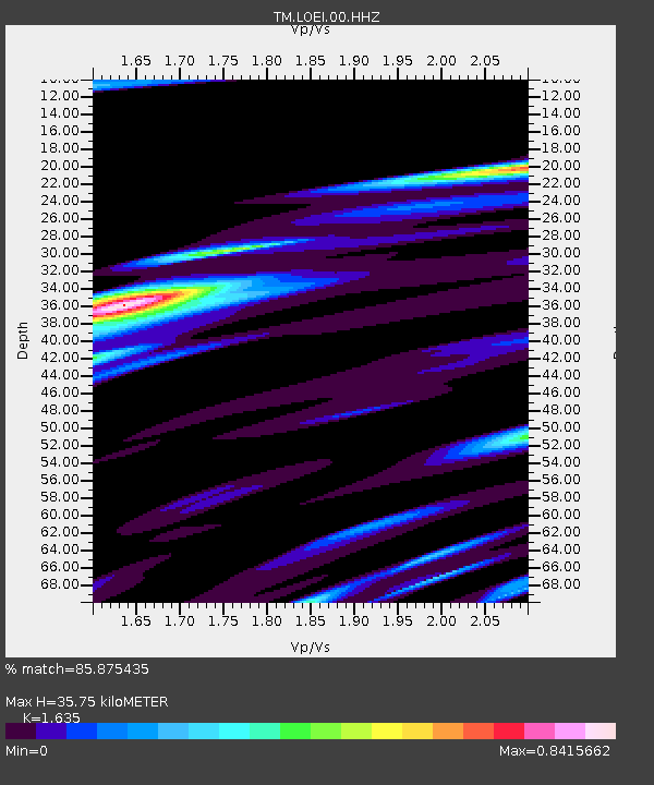
| Estimated Moho Depth: |
35.75 km |
| Estimated Crust Vp/Vs: |
1.63 |
| Assumed Crust Vp: |
6.35 km/s |
| Estimated Crust Vs: |
3.884 km/s |
| Estimated Crust Poisson's Ratio: |
0.20 |
|
| Radial Match: |
85.875435 % |
| Radial Bump: |
400 |
| Transverse Match: |
70.667854 % |
| Transverse Bump: |
400 |
| SOD ConfigId: |
31937991 |
| Insert Time: |
2023-10-22 18:21:55.944 +0000 |
| GWidth: |
2.5 |
| Max Bumps: |
400 |
| Tol: |
0.001 |
|

Signal To Noise
| Channel | StoN | STA | LTA |
| TM:LOEI:00:HHZ:20231008T18:16:07.880Z | 0.6804225 | 1.9573298E-7 | 2.8766388E-7 |
| TM:LOEI:00:HHN:20231008T18:16:07.880Z | 1.4821458 | 1.12983045E-7 | 7.622938E-8 |
| TM:LOEI:00:HHE:20231008T18:16:07.880Z | 1.5560653 | 1.6629201E-7 | 1.06866985E-7 |
| Arrivals |
| Ps | 3.8 SECOND |
| PpPs | 14 SECOND |
| PsPs/PpSs | 18 SECOND |


