You are here: Home > Network List > IW - Intermountain West Stations List
> Station IMW Indian Meadow, Wyoming, USA > Earthquake Result Viewer
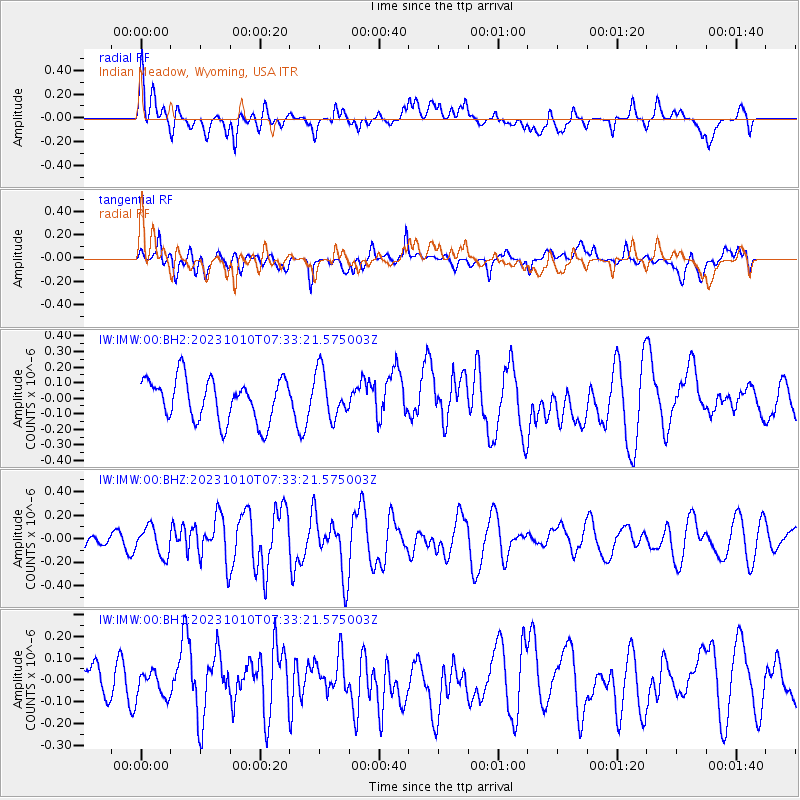
IMW Indian Meadow, Wyoming, USA - Earthquake Result Viewer
*The percent match for this event was below the threshold and hence no stack was calculated.
| Earthquake location: |
Tonga Islands |
| Earthquake latitude/longitude: |
-15.5/-174.2 |
| Earthquake time(UTC): |
2023/10/10 (283) 07:21:32 GMT |
| Earthquake Depth: |
25 km |
| Earthquake Magnitude: |
5.7 Mww |
| Earthquake Catalog/Contributor: |
NEIC PDE/us |
|
| Network: |
IW Intermountain West |
| Station: |
IMW Indian Meadow, Wyoming, USA |
| Lat/Lon: |
43.90 N/110.94 W |
| Elevation: |
2646 m |
|
| Distance: |
82.6 deg |
| Az: |
40.624 deg |
| Baz: |
240.241 deg |
| Ray Param: |
$rayparam |
*The percent match for this event was below the threshold and hence was not used in the summary stack. |
|
| Radial Match: |
57.997086 % |
| Radial Bump: |
400 |
| Transverse Match: |
66.454254 % |
| Transverse Bump: |
400 |
| SOD ConfigId: |
31937991 |
| Insert Time: |
2023-10-24 07:35:11.942 +0000 |
| GWidth: |
2.5 |
| Max Bumps: |
400 |
| Tol: |
0.001 |
|
Signal To Noise
| Channel | StoN | STA | LTA |
| IW:IMW:00:BHZ:20231010T07:33:21.575003Z | 0.9589926 | 1.2171932E-7 | 1.2692416E-7 |
| IW:IMW:00:BH1:20231010T07:33:21.575003Z | 0.5370044 | 5.659404E-8 | 1.0538841E-7 |
| IW:IMW:00:BH2:20231010T07:33:21.575003Z | 1.106284 | 1.507717E-7 | 1.362866E-7 |
| Arrivals |
| Ps | |
| PpPs | |
| PsPs/PpSs | |


