You are here: Home > Network List > CI - Caltech Regional Seismic Network Stations List
> Station BAR Barrett, Tecate, CA, USA > Earthquake Result Viewer
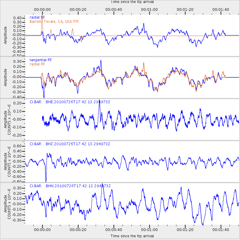
BAR Barrett, Tecate, CA, USA - Earthquake Result Viewer
*The percent match for this event was below the threshold and hence no stack was calculated.
| Earthquake location: |
Salta Province, Argentina |
| Earthquake latitude/longitude: |
-24.1/-66.8 |
| Earthquake time(UTC): |
2010/07/26 (207) 17:31:31 GMT |
| Earthquake Depth: |
193 km |
| Earthquake Magnitude: |
5.6 MW, 5.3 MB, 5.5 MW |
| Earthquake Catalog/Contributor: |
WHDF/NEIC |
|
| Network: |
CI Caltech Regional Seismic Network |
| Station: |
BAR Barrett, Tecate, CA, USA |
| Lat/Lon: |
32.68 N/116.67 W |
| Elevation: |
521 m |
|
| Distance: |
73.8 deg |
| Az: |
317.832 deg |
| Baz: |
133.306 deg |
| Ray Param: |
$rayparam |
*The percent match for this event was below the threshold and hence was not used in the summary stack. |
|
| Radial Match: |
41.42455 % |
| Radial Bump: |
400 |
| Transverse Match: |
47.425793 % |
| Transverse Bump: |
400 |
| SOD ConfigId: |
319893 |
| Insert Time: |
2011-01-05 12:35:31.743 +0000 |
| GWidth: |
2.5 |
| Max Bumps: |
400 |
| Tol: |
0.001 |
|
Signal To Noise
| Channel | StoN | STA | LTA |
| CI:BAR: :BHZ:20100726T17:42:13.294973Z | 2.504605 | 2.8121488E-7 | 1.12279125E-7 |
| CI:BAR: :BHN:20100726T17:42:13.294973Z | 0.71254784 | 9.574614E-8 | 1.3437152E-7 |
| CI:BAR: :BHE:20100726T17:42:13.294973Z | 1.9657276 | 9.975106E-8 | 5.074511E-8 |
| Arrivals |
| Ps | |
| PpPs | |
| PsPs/PpSs | |


