You are here: Home > Network List > CI - Caltech Regional Seismic Network Stations List
> Station GLA Glamis, Glamis, CA, USA > Earthquake Result Viewer
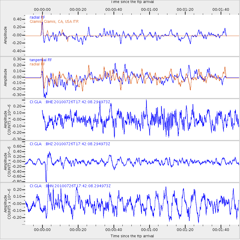
GLA Glamis, Glamis, CA, USA - Earthquake Result Viewer
*The percent match for this event was below the threshold and hence no stack was calculated.
| Earthquake location: |
Salta Province, Argentina |
| Earthquake latitude/longitude: |
-24.1/-66.8 |
| Earthquake time(UTC): |
2010/07/26 (207) 17:31:31 GMT |
| Earthquake Depth: |
193 km |
| Earthquake Magnitude: |
5.6 MW, 5.3 MB, 5.5 MW |
| Earthquake Catalog/Contributor: |
WHDF/NEIC |
|
| Network: |
CI Caltech Regional Seismic Network |
| Station: |
GLA Glamis, Glamis, CA, USA |
| Lat/Lon: |
33.05 N/114.83 W |
| Elevation: |
610 m |
|
| Distance: |
72.9 deg |
| Az: |
319.236 deg |
| Baz: |
134.705 deg |
| Ray Param: |
$rayparam |
*The percent match for this event was below the threshold and hence was not used in the summary stack. |
|
| Radial Match: |
60.29225 % |
| Radial Bump: |
400 |
| Transverse Match: |
68.42788 % |
| Transverse Bump: |
400 |
| SOD ConfigId: |
319893 |
| Insert Time: |
2011-01-05 12:35:47.391 +0000 |
| GWidth: |
2.5 |
| Max Bumps: |
400 |
| Tol: |
0.001 |
|
Signal To Noise
| Channel | StoN | STA | LTA |
| CI:GLA: :BHZ:20100726T17:42:08.294973Z | 4.4006095 | 2.9779756E-7 | 6.767189E-8 |
| CI:GLA: :BHN:20100726T17:42:08.294973Z | 1.6962708 | 1.25723E-7 | 7.411729E-8 |
| CI:GLA: :BHE:20100726T17:42:08.294973Z | 1.5219216 | 9.725632E-8 | 6.3903634E-8 |
| Arrivals |
| Ps | |
| PpPs | |
| PsPs/PpSs | |


