You are here: Home > Network List > US - United States National Seismic Network Stations List
> Station MIAR Mount Ida, Arkansas, USA > Earthquake Result Viewer
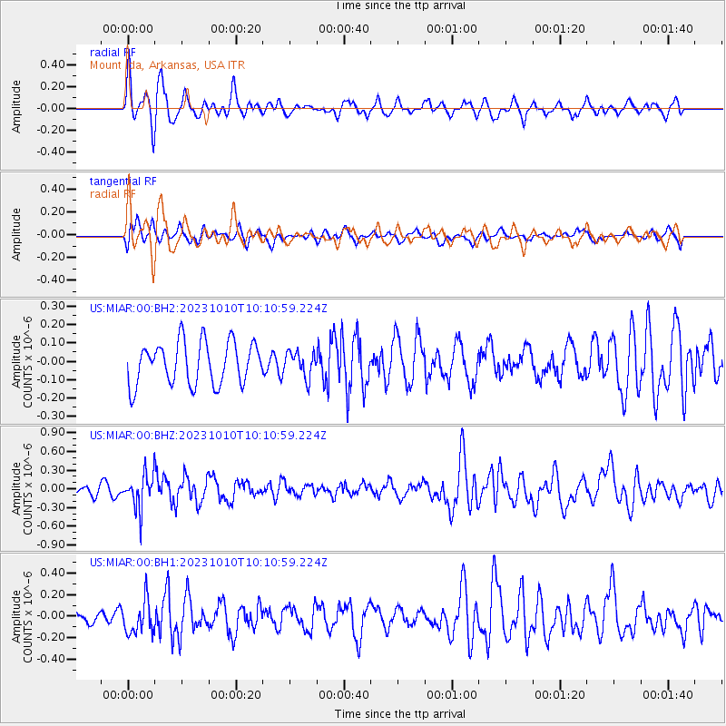
MIAR Mount Ida, Arkansas, USA - Earthquake Result Viewer
*The percent match for this event was below the threshold and hence no stack was calculated.
| Earthquake location: |
Jujuy Province, Argentina |
| Earthquake latitude/longitude: |
-22.9/-66.2 |
| Earthquake time(UTC): |
2023/10/10 (283) 10:01:31 GMT |
| Earthquake Depth: |
247 km |
| Earthquake Magnitude: |
6.0 Mww |
| Earthquake Catalog/Contributor: |
NEIC PDE/us |
|
| Network: |
US United States National Seismic Network |
| Station: |
MIAR Mount Ida, Arkansas, USA |
| Lat/Lon: |
34.55 N/93.58 W |
| Elevation: |
207 m |
|
| Distance: |
62.7 deg |
| Az: |
334.747 deg |
| Baz: |
151.535 deg |
| Ray Param: |
$rayparam |
*The percent match for this event was below the threshold and hence was not used in the summary stack. |
|
| Radial Match: |
71.338165 % |
| Radial Bump: |
400 |
| Transverse Match: |
54.4073 % |
| Transverse Bump: |
400 |
| SOD ConfigId: |
31937991 |
| Insert Time: |
2023-10-24 10:27:39.886 +0000 |
| GWidth: |
2.5 |
| Max Bumps: |
400 |
| Tol: |
0.001 |
|
Signal To Noise
| Channel | StoN | STA | LTA |
| US:MIAR:00:BHZ:20231010T10:10:59.224Z | 2.3569536 | 2.740942E-7 | 1.1629173E-7 |
| US:MIAR:00:BH1:20231010T10:10:59.224Z | 2.1626174 | 1.544088E-7 | 7.139903E-8 |
| US:MIAR:00:BH2:20231010T10:10:59.224Z | 0.59576845 | 6.896541E-8 | 1.1575876E-7 |
| Arrivals |
| Ps | |
| PpPs | |
| PsPs/PpSs | |


