You are here: Home > Network List > TA - USArray Transportable Network (new EarthScope stations) Stations List
> Station I19A Meeteetse, WY, USA > Earthquake Result Viewer
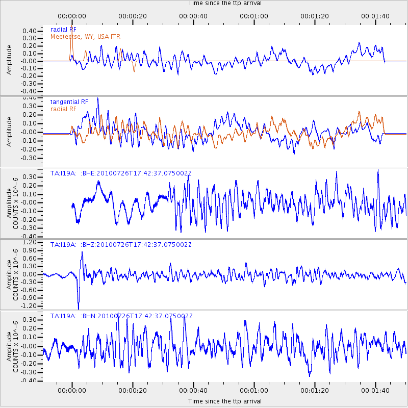
I19A Meeteetse, WY, USA - Earthquake Result Viewer
*The percent match for this event was below the threshold and hence no stack was calculated.
| Earthquake location: |
Salta Province, Argentina |
| Earthquake latitude/longitude: |
-24.1/-66.8 |
| Earthquake time(UTC): |
2010/07/26 (207) 17:31:31 GMT |
| Earthquake Depth: |
193 km |
| Earthquake Magnitude: |
5.6 MW, 5.3 MB, 5.5 MW |
| Earthquake Catalog/Contributor: |
WHDF/NEIC |
|
| Network: |
TA USArray Transportable Network (new EarthScope stations) |
| Station: |
I19A Meeteetse, WY, USA |
| Lat/Lon: |
44.04 N/108.99 W |
| Elevation: |
1982 m |
|
| Distance: |
78.0 deg |
| Az: |
330.331 deg |
| Baz: |
141.14 deg |
| Ray Param: |
$rayparam |
*The percent match for this event was below the threshold and hence was not used in the summary stack. |
|
| Radial Match: |
51.376797 % |
| Radial Bump: |
400 |
| Transverse Match: |
57.351566 % |
| Transverse Bump: |
400 |
| SOD ConfigId: |
319893 |
| Insert Time: |
2011-01-05 12:45:01.023 +0000 |
| GWidth: |
2.5 |
| Max Bumps: |
400 |
| Tol: |
0.001 |
|
Signal To Noise
| Channel | StoN | STA | LTA |
| TA:I19A: :BHZ:20100726T17:42:37.075002Z | 6.0461674 | 4.6783097E-7 | 7.737645E-8 |
| TA:I19A: :BHN:20100726T17:42:37.075002Z | 0.9941792 | 1.0380049E-7 | 1.0440822E-7 |
| TA:I19A: :BHE:20100726T17:42:37.075002Z | 1.0490184 | 1.2808088E-7 | 1.2209593E-7 |
| Arrivals |
| Ps | |
| PpPs | |
| PsPs/PpSs | |


