You are here: Home > Network List > CN - Canadian National Seismograph Network Stations List
> Station FCC Fort Churchill, MB, CA > Earthquake Result Viewer
FCC Fort Churchill, MB, CA - Earthquake Result Viewer
| Earthquake location: |
Northwestern Afghanistan |
| Earthquake latitude/longitude: |
34.6/62.1 |
| Earthquake time(UTC): |
2023/10/11 (284) 00:41:56 GMT |
| Earthquake Depth: |
10 km |
| Earthquake Magnitude: |
6.3 Mww |
| Earthquake Catalog/Contributor: |
NEIC PDE/us |
|
| Network: |
CN Canadian National Seismograph Network |
| Station: |
FCC Fort Churchill, MB, CA |
| Lat/Lon: |
58.76 N/94.09 W |
| Elevation: |
39 m |
|
| Distance: |
84.9 deg |
| Az: |
347.79 deg |
| Baz: |
19.563 deg |
| Ray Param: |
0.045155466 |
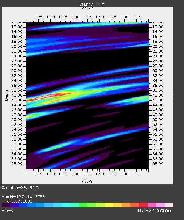
| Estimated Moho Depth: |
40.5 km |
| Estimated Crust Vp/Vs: |
1.67 |
| Assumed Crust Vp: |
6.455 km/s |
| Estimated Crust Vs: |
3.866 km/s |
| Estimated Crust Poisson's Ratio: |
0.22 |
|
| Radial Match: |
89.99472 % |
| Radial Bump: |
400 |
| Transverse Match: |
75.29001 % |
| Transverse Bump: |
400 |
| SOD ConfigId: |
31937991 |
| Insert Time: |
2023-10-25 00:55:12.023 +0000 |
| GWidth: |
2.5 |
| Max Bumps: |
400 |
| Tol: |
0.001 |
|

Signal To Noise
| Channel | StoN | STA | LTA |
| CN:FCC: :HHZ:20231011T00:53:59.820Z | 6.9887424 | 2.1382368E-6 | 3.0595444E-7 |
| CN:FCC: :HHN:20231011T00:53:59.820Z | 3.2314324 | 6.8671943E-7 | 2.1251238E-7 |
| CN:FCC: :HHE:20231011T00:53:59.820Z | 3.5543551 | 5.172026E-7 | 1.4551235E-7 |
| Arrivals |
| Ps | 4.3 SECOND |
| PpPs | 16 SECOND |
| PsPs/PpSs | 21 SECOND |


