You are here: Home > Network List > TA - USArray Transportable Network (new EarthScope stations) Stations List
> Station T30A Plains, KS, USA > Earthquake Result Viewer
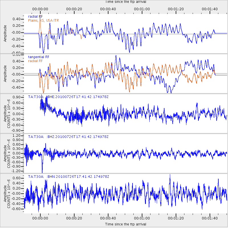
T30A Plains, KS, USA - Earthquake Result Viewer
*The percent match for this event was below the threshold and hence no stack was calculated.
| Earthquake location: |
Salta Province, Argentina |
| Earthquake latitude/longitude: |
-24.1/-66.8 |
| Earthquake time(UTC): |
2010/07/26 (207) 17:31:31 GMT |
| Earthquake Depth: |
193 km |
| Earthquake Magnitude: |
5.6 MW, 5.3 MB, 5.5 MW |
| Earthquake Catalog/Contributor: |
WHDF/NEIC |
|
| Network: |
TA USArray Transportable Network (new EarthScope stations) |
| Station: |
T30A Plains, KS, USA |
| Lat/Lon: |
37.05 N/100.53 W |
| Elevation: |
778 m |
|
| Distance: |
68.6 deg |
| Az: |
331.519 deg |
| Baz: |
146.981 deg |
| Ray Param: |
$rayparam |
*The percent match for this event was below the threshold and hence was not used in the summary stack. |
|
| Radial Match: |
58.85431 % |
| Radial Bump: |
400 |
| Transverse Match: |
45.99734 % |
| Transverse Bump: |
400 |
| SOD ConfigId: |
319893 |
| Insert Time: |
2011-01-05 12:53:13.284 +0000 |
| GWidth: |
2.5 |
| Max Bumps: |
400 |
| Tol: |
0.001 |
|
Signal To Noise
| Channel | StoN | STA | LTA |
| TA:T30A: :BHZ:20100726T17:41:42.174978Z | 1.7704307 | 3.676678E-7 | 2.076714E-7 |
| TA:T30A: :BHN:20100726T17:41:42.174978Z | 1.3473465 | 2.9964187E-7 | 2.2239406E-7 |
| TA:T30A: :BHE:20100726T17:41:42.174978Z | 0.7048011 | 2.1084608E-7 | 2.9915688E-7 |
| Arrivals |
| Ps | |
| PpPs | |
| PsPs/PpSs | |


