You are here: Home > Network List > PQ - Public Safety Geoscience Program Canadian Research Network (PSGP) Stations List
> Station TSIIG Tsiigehtchic, Northwest Territory > Earthquake Result Viewer
TSIIG Tsiigehtchic, Northwest Territory - Earthquake Result Viewer
| Earthquake location: |
Northwestern Afghanistan |
| Earthquake latitude/longitude: |
34.6/62.1 |
| Earthquake time(UTC): |
2023/10/11 (284) 00:41:56 GMT |
| Earthquake Depth: |
10 km |
| Earthquake Magnitude: |
6.3 Mww |
| Earthquake Catalog/Contributor: |
NEIC PDE/us |
|
| Network: |
PQ Public Safety Geoscience Program Canadian Research Network (PSGP) |
| Station: |
TSIIG Tsiigehtchic, Northwest Territory |
| Lat/Lon: |
67.44 N/133.74 W |
| Elevation: |
56 m |
|
| Distance: |
77.6 deg |
| Az: |
6.18 deg |
| Baz: |
346.689 deg |
| Ray Param: |
0.05022914 |
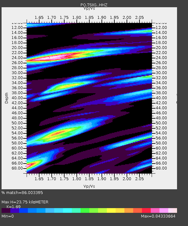
| Estimated Moho Depth: |
23.75 km |
| Estimated Crust Vp/Vs: |
1.69 |
| Assumed Crust Vp: |
6.171 km/s |
| Estimated Crust Vs: |
3.652 km/s |
| Estimated Crust Poisson's Ratio: |
0.23 |
|
| Radial Match: |
86.003395 % |
| Radial Bump: |
400 |
| Transverse Match: |
80.93971 % |
| Transverse Bump: |
379 |
| SOD ConfigId: |
31937991 |
| Insert Time: |
2023-10-25 01:03:34.706 +0000 |
| GWidth: |
2.5 |
| Max Bumps: |
400 |
| Tol: |
0.001 |
|

Signal To Noise
| Channel | StoN | STA | LTA |
| PQ:TSIIG: :HHZ:20231011T00:53:21.119988Z | 14.01334 | 2.704875E-6 | 1.9302144E-7 |
| PQ:TSIIG: :HHN:20231011T00:53:21.119988Z | 3.175024 | 9.519019E-7 | 2.9980936E-7 |
| PQ:TSIIG: :HHE:20231011T00:53:21.119988Z | 0.92289996 | 1.8079345E-7 | 1.9589713E-7 |
| Arrivals |
| Ps | 2.7 SECOND |
| PpPs | 10 SECOND |
| PsPs/PpSs | 13 SECOND |


